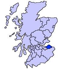
File:ScotlandEastLothian.png
Appearance
ScotlandEastLothian.png (200 × 230 pixels, file size: 4 KB, MIME type: image/png)
File history
Click on a date/time to view the file as it appeared at that time.
| Date/Time | Thumbnail | Dimensions | User | Comment | |
|---|---|---|---|---|---|
| current | 21:33, 17 May 2005 |  | 200 × 230 (4 KB) | Voyager | East Lothian unitary council Slightly edited version of a map drawn by Morwen {{GFDL}} Category:Maps of Scottish unitary councils |
File usage
The following 3 pages use this file:
Global file usage
The following other wikis use this file:
- Usage on ar.wikipedia.org
- Usage on ast.wikipedia.org
- Usage on be.wikipedia.org
- Usage on bg.wikipedia.org
- Usage on ca.wikipedia.org
- Usage on cy.wikipedia.org
- Usage on da.wikipedia.org
- Usage on de.wikipedia.org
- Usage on eu.wikipedia.org
- Ekialdeko Lothian
- Lankide:Euskaldunaa
- Haddington (Eskozia)
- Musselburgh
- Dunbar
- Txantiloi:Ekialdeko Lothian
- Aberlady
- Athelstaneford
- Auldhame eta Scoughall
- Bolton (Ekialdeko Lothian)
- Cockenzie eta Port Seton
- Dirleton
- Drem
- East Linton
- Whitekirk eta Tyninghame
- Wallyford
- East Saltoun eta West Saltoun
- Gifford (Ekialdeko Lothian)
- Gullane
- Wikiproiektu:Irlanda, Gales eta Eskoziako udalerriak
- Ballencrieff (Ekialdeko Lothian)
- North Berwick
- Prestonpans
- Tranent
- Bara (Ekialdeko Lothian)
- Belhaven (Eskozia)
- Biel (Ekialdeko Lothian)
- Bilsdean
- Broxburn (Ekialdeko Lothian)
- Canty Bay
- Carberry (Ekialdeko Lothian)
- Dunglass
- East Fortune
- Elphinstone (Ekialdeko Lothian)
- Garvald (Ekialdeko Lothian)
- Gladsmuir
- Humbie
- Innerwick
- Inveresk
- Kingston (Ekialdeko Lothian)
- Longniddry
- Macmerry
View more global usage of this file.


