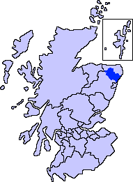
File:ScotlandAberdeenshireFormartine.png
Appearance
ScotlandAberdeenshireFormartine.png (191 × 261 pixels, file size: 4 KB, MIME type: image/png)
File history
Click on a date/time to view the file as it appeared at that time.
| Date/Time | Thumbnail | Dimensions | User | Comment | |
|---|---|---|---|---|---|
| current | 01:07, 8 November 2007 |  | 191 × 261 (4 KB) | Harami2000 | == Summary == == Summary == {{Information |Description= Aberdeenshire unitary council - Formartine Area |Source= Slightly edited version of a map drawn by Morwen and Voyager |Date= |Author= |Permission= |other_ve |
File usage
The following 44 pages use this file:
- Auchterless
- Balmedie
- Barthol Chapel
- Belhelvie
- Blackdog
- Bogton
- Cairnorrie
- Collieston
- Craigdam
- Craigston Castle
- Cuminestown
- Delgatie Castle
- Ellon, Aberdeenshire
- Esslemont Castle
- Formartine
- Formartine and Buchan Way
- Forvie National Nature Reserve
- Foveran
- Fyvie
- Fyvie Castle
- Garmond, Aberdeenshire
- Gight
- Gordonstown, Formartine
- Haddo House
- Inverkeithny
- Knockhall Castle
- Methlick
- Newburgh, Aberdeenshire
- Oldmeldrum
- Pitmedden
- Pitmedden Garden
- Potterton
- Rothienorman
- Tarves
- Tolquhon Castle
- Turriff
- Udny Green
- Udny Station
- Whitecairns
- Whiterashes
- Woodhead, Aberdeenshire
- Ythan Estuary
- Ythanbank
- Template:Formartine, Aberdeenshire places
Global file usage
The following other wikis use this file:
- Usage on ga.wikipedia.org


