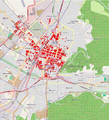
File:Schadenskarte Operation Tigerfish 27.11.1944.png
Appearance

Size of this preview: 546 × 599 pixels. Other resolutions: 219 × 240 pixels | 437 × 480 pixels | 700 × 768 pixels | 1,136 × 1,247 pixels.
Original file (1,136 × 1,247 pixels, file size: 2.13 MB, MIME type: image/png)
File history
Click on a date/time to view the file as it appeared at that time.
| Date/Time | Thumbnail | Dimensions | User | Comment | |
|---|---|---|---|---|---|
| current | 18:59, 17 April 2010 |  | 1,136 × 1,247 (2.13 MB) | Dr. med. Mabuse | {{Information |Description={{en|1=amage map of operation tigerfish 27th november 1944. Totally destroyed areas are marked red. Map is based on Map M14 Nr. 89 cityarchive Freiburg. This map may be incomplete, and may contain errors. Don't rely solely on it |
File usage
The following page uses this file:
Global file usage
The following other wikis use this file:
- Usage on de.wikipedia.org
- Usage on fr.wikipedia.org
- Usage on www.wikidata.org

