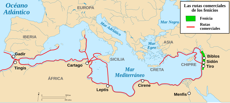
File:Rutas comerciales fenicias-es.svg
Appearance

Size of this PNG preview of this SVG file: 800 × 359 pixels. Other resolutions: 320 × 144 pixels | 640 × 287 pixels | 1,024 × 460 pixels | 1,280 × 575 pixels | 2,560 × 1,150 pixels | 2,042 × 917 pixels.
Original file (SVG file, nominally 2,042 × 917 pixels, file size: 450 KB)
File history
Click on a date/time to view the file as it appeared at that time.
| Date/Time | Thumbnail | Dimensions | User | Comment | |
|---|---|---|---|---|---|
| current | 18:56, 19 November 2019 |  | 2,042 × 917 (450 KB) | Rowanwindwhistler | Fake text added |
| 23:03, 12 April 2012 |  | 2,042 × 917 (366 KB) | Alelapenya | Corrección de topónimos. Ibéria por Iberia; Gádir por Gadir; Tangis por Tingis y Lepcis por Leptis | |
| 12:44, 21 March 2010 |  | 2,042 × 917 (366 KB) | Rodriguín | Category:History of Spain | |
| 18:30, 6 January 2010 |  | 2,042 × 917 (366 KB) | Rodriguín | {{Information |Description={{fr|Cartes des routes commerciales des Phéniciens.}} {{en|Trade routes of the Phoenicians.}}{{es|Carta en la que se presentan algunas de las rutas comerciales fenicias.}} |
File usage
The following page uses this file:
Global file usage
The following other wikis use this file:
- Usage on ast.wikipedia.org
- Usage on ca.wikipedia.org
- Usage on de.wikipedia.org
- Usage on en.wikibooks.org
- Usage on eo.wikipedia.org
- Usage on es.wikipedia.org
- Usage on fa.wikipedia.org
- Usage on it.wikipedia.org
- Usage on oc.wikipedia.org


