Jump to content

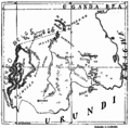
File:Ruanda Prov 1912 B002a.png

Page contents not supported in other languages.
This is a file from the Wikimedia Commons
From Wikipedia, the free encyclopedia

Original file (1,845 × 1,818 pixels, file size: 946 KB, MIME type: image/png)

Description
English: Map of the Ruanda area of the then German colony "German East Africa" with important lakes, provinces and localities mentionned in the given article
Français : Original caption: "
Carte du Ruanda où sont indiqués le noms des provinces et des localités cités dans cet article
"
Deutsch: Karte des Ruanda-Gebiets der damaligen Kolonie Deutsch-Ostafrika mit wichtigen Seen, Provinzen und Örtlichkeiten, sofern diese im oben genannten Artikel erwähnt werden
Date
Source Alexandre Arnoux, "Le Culte de la Société Secrète des Imandwa au Ruanda", In: Anthropos (St.Gabriel-Mödling bei Wien), vol.7, No.3, 1912, p.273ff.
Author Alexandre Arnoux (Padre de Pères Blancs en Kabgayi)
Permission
(Reusing this file)
Public domain

This work is in the public domain in its country of origin and other countries and areas where the copyright term is the author's life plus 70 years or fewer.


You must also include a United States public domain tag to indicate why this work is in the public domain in the United States.
This file has been identified as being free of known restrictions under copyright law, including all related and neighboring rights.

B.E.A. = British East Africa

Français : Aux nombres dans la carte (original):
1: Kigáli; 2: Nánza; 3: Kabgáyi; 4: Isávi; 5: Núndo; 6: Nzáza; 7: Ruáza; 8 Mibirizi; 9: Ruhindo: 10: Karisimbi, volcan; 11: Kahinga, id.; 12: Sabino, id.; 13: Segéša, id.; 14: Ndéndule, id.; 15: Múkurumúbi, id.; 16: Niragongo; 17: Burágurabána; 18: Bihána; 19: Kitisi; 20: Ku Runšúnšu; 21: Muzirángegera; 22: Akákibogo; 23 Kúli kágono; 24: Ngamba; 25: Mášoza ya Kimana; 26: Kwa širangabo; 27: Muširarungu; 28: Ngowa, Cong.B.; 29: Kisenyi; 30: Bukambo; 31: Bisóko; 31: Bisòko; 32: Intémbabagóyi; 33: Sources d'eau chaude; 34: Kwa Nirakahúmuza; 35: Mwúlire; 36 Buzégezege bgo harúguru; 37: Kimámagana; 38: Naruténgeli

Captions

Add a one-line explanation of what this file represents

Items portrayed in this file

depicts

File history

Click on a date/time to view the file as it appeared at that time.

Date/TimeThumbnailDimensionsUserComment
current13:41, 29 June 2016Thumbnail for version as of 13:41, 29 June 20161,845 × 1,818 (946 KB)Katharinaiv{{Information |Description ={{en|1=Map of the Ruanda area of the then german colony "German East Africa" with important lakes, provinces and localities mentionned in the given article}} {{fr|1={{original caption|Carte du Ruanda où sond indiqués le...

The following 2 pages use this file:

Global file usage

The following other wikis use this file:

Metadata