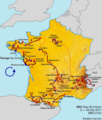
File:Route of the 2011 Tour de France.png
Appearance

Size of this preview: 599 × 600 pixels. Other resolutions: 240 × 240 pixels | 479 × 480 pixels | 767 × 768 pixels | 1,023 × 1,024 pixels | 2,045 × 2,048 pixels | 3,198 × 3,202 pixels.
Original file (3,198 × 3,202 pixels, file size: 2.73 MB, MIME type: image/png)
File history
Click on a date/time to view the file as it appeared at that time.
| Date/Time | Thumbnail | Dimensions | User | Comment | |
|---|---|---|---|---|---|
| current | 00:25, 21 November 2016 |  | 3,198 × 3,202 (2.73 MB) | Andrei loas | Removed copyright text and distance. |
| 04:18, 23 April 2016 |  | 3,198 × 3,202 (2.76 MB) | Andrei loas | Decreased size of stage buttons to match all other maps. | |
| 04:26, 8 December 2011 |  | 3,198 × 3,202 (2.77 MB) | Andrei loas | Updated metadata | |
| 22:24, 12 November 2011 |  | 3,198 × 3,202 (2.77 MB) | Andrei loas | Moved into higher resolution map | |
| 21:13, 10 November 2011 |  | 3,162 × 3,718 (2.42 MB) | Andrei loas | Corrected Saint-Gaudens instead of Saint-Girons, minor edits. | |
| 07:35, 10 November 2011 |  | 3,162 × 3,718 (2.41 MB) | Andrei loas | {{Information |Description ={{en|1=Route of the 2011 Tour de France created by me using Inkscape vectors superimposed on a France model}} |Source ={{own}} |Author =Andrei I. Loas |Date =2011-11-10 |Permission = |other_vers |
File usage
The following 3 pages use this file:
Global file usage
The following other wikis use this file:
- Usage on fy.wikipedia.org
- Usage on hr.wikipedia.org
- Usage on it.wikipedia.org
- Usage on lv.wikipedia.org
- Usage on mk.wikipedia.org
- Usage on sl.wikipedia.org
- Usage on sv.wikipedia.org
