
File:Rotorua.Caldera.Mount.Tarawera.JPG
Original file (1,280 × 948 pixels, file size: 399 KB, MIME type: image/jpeg)
| This is a file from the Wikimedia Commons. Information from its description page there is shown below. Commons is a freely licensed media file repository. You can help. |
| Description |
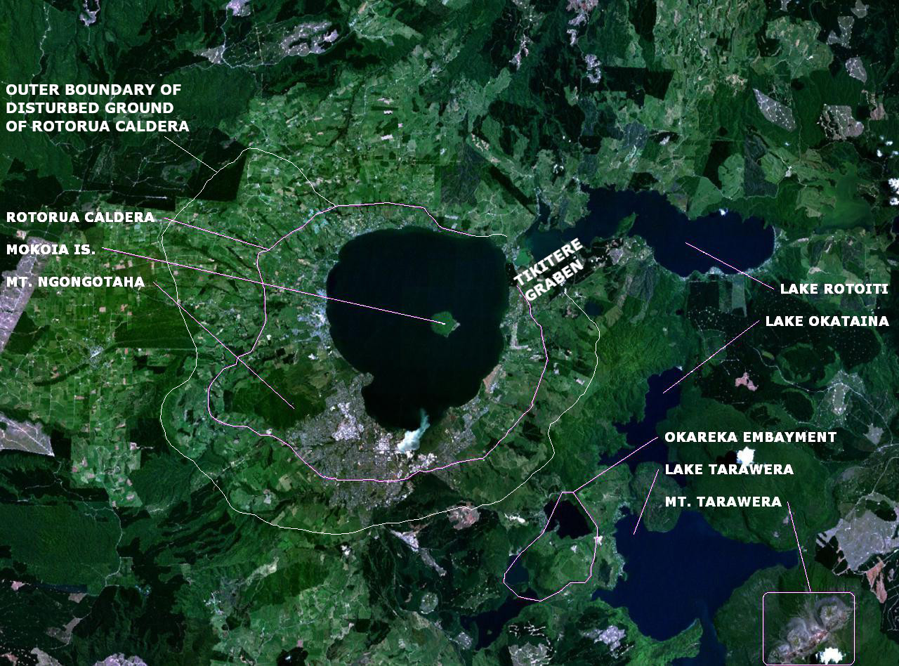
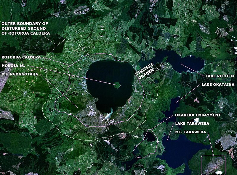
English: en:NASA World Wind false-colour landsat-7 composite satellite photo of en:Lake Rotorua in en:New Zealand. en:Category:Taupo Volcanic Zone |
| Date | (UTC) |
| Source | |
| Author |
|
Annotations based on: Newhall, Christopher G.; Dzurisin, Daniel (1988), Historical unrest at large calderas of the world, USGS Bulletin 1855, p. 1108 [1] archive copy at the Wayback Machine; Hodgson, K. A. and Nairn, I. A. (2004). The Sedimentation and Drainage History of Haroharo Caldera and The Tarawera River System, Taupo Volcanic Zone, New Zealand, Operations Publication 2004/03, Environment Bay of Plenty, August 2004. ISSN 1176 - 5550. Page 7.[2]. Corrections based on Milner,David M. The structure and eruptive history of Rotorua Caldera, Taupo Volcanic Zone, New Zealand (2001).
| This is a retouched picture, which means that it has been digitally altered from its original version. Modifications: Labels. The original can be viewed here: Lake rotorua.jpg:
|
| This image is in the public domain because it is a screenshot from NASA’s globe software World Wind using a public domain layer, such as Blue Marble, MODIS, Landsat, SRTM, USGS or GLOBE.
|
 |
Original upload log
This image is a derivative work of the following images:
- File:Lake_rotorua.jpg licensed with PD-USGov-NASA
- 2008-01-03T16:16:53Z Rémih 1280x948 (227865 Bytes) {{Information |Description={{en|[[:en:NASA World Wind]] false-colour landsat-7 composite satellite photo of [[:en:Lake Rotorua]] in [[:en:New Zealand]]. [[:en:Category:Taupo Volcanic Zone]]}} |Source=Transfered from [http://e
Uploaded with derivativeFX
File history
Click on a date/time to view the file as it appeared at that time.
| Date/Time | Thumbnail | Dimensions | User | Comment | |
|---|---|---|---|---|---|
| current | 19:33, 14 August 2022 | | 1,280 × 948 (399 KB) | ChaseKiwi | Caldera outline corrected, Tikitere Graben added to explain gap in Caldera |
| 09:38, 25 February 2010 |  | 1,280 × 948 (238 KB) | Chris.urs-o | Improved labelling | |
| 20:22, 24 February 2010 |  | 1,280 × 948 (235 KB) | Chris.urs-o | {{Information |Description={{en|en:NASA World Wind false-colour landsat-7 composite satellite photo of en:Lake Rotorua in en:New Zealand. en:Category:Taupo Volcanic Zone}} |Source=*File:Lake_rotorua.jpg |Date=2010-02-24 20:15 (UT |
File usage
The following 3 pages use this file:
Global file usage
The following other wikis use this file:
- Usage on de.wikipedia.org
- Usage on it.wikipedia.org