File:Rota do âmbar.jpg
Appearance
Rota_do_âmbar.jpg (411 × 599 pixels, file size: 69 KB, MIME type: image/jpeg)
File history
Click on a date/time to view the file as it appeared at that time.
| Date/Time | Thumbnail | Dimensions | User | Comment | |
|---|---|---|---|---|---|
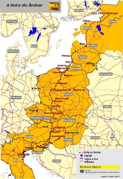
| current | 03:41, 27 August 2006 |  | 411 × 599 (69 KB) | Bonas | Amber Road on the map of Europe. Source: Map of the Amber Road in Portuguese. PD map taken from de:Bild:Bernsteinstrasse.jpg and modified by me. Uploaded by: User:Bonas Amber Road [[Category:O |
File usage
No pages on the English Wikipedia use this file (pages on other projects are not listed).
Global file usage
The following other wikis use this file:
- Usage on an.wikipedia.org
- Usage on be.wikipedia.org
- Usage on da.wikipedia.org
- Usage on eo.wikipedia.org
- Usage on es.wikipedia.org
- Usage on et.wikipedia.org
- Usage on hr.wikipedia.org
- Usage on it.wikivoyage.org
- Usage on ko.wikipedia.org
- Usage on la.wikipedia.org
- Usage on mk.wikipedia.org
- Usage on pl.wikipedia.org
- Usage on pt.wikipedia.org
- Usage on sh.wikipedia.org
- Usage on sk.wikipedia.org
- Usage on sr.wikipedia.org
- Usage on sv.wikipedia.org
- Usage on th.wikipedia.org
- Usage on uk.wikipedia.org
- Соляний шлях (Україна)
- Шлях із варягів у греки
- Бурштин
- Ганза
- Торгівля
- Великий шовковий шлях
- Манільські галеони
- Римські дороги
- Трикутникова торгівля
- Сибірський тракт
- Бурштиновий шлях
- Соляний шлях
- Шаблон:Історичні торговельні шляхи
- Via Maris
- Via Regia (Азія)
- Шлях пахощів
- Дорога спецій
- Великий колісний шлях
- Дороги інків
- Олов'яний шлях
- Волзький торговий шлях
- Індо-римська торгівля
- Царська дорога Персії
- Via Regia (Європа)
View more global usage of this file.


