
File:Roman Empire full map.jpg

Size of this preview: 742 × 599 pixels. Other resolutions: 297 × 240 pixels | 594 × 480 pixels | 951 × 768 pixels | 1,166 × 942 pixels.
Original file (1,166 × 942 pixels, file size: 367 KB, MIME type: image/jpeg)
| This is a file from the Wikimedia Commons. Information from its description page there is shown below. Commons is a freely licensed media file repository. You can help. |
Summary
| Description |
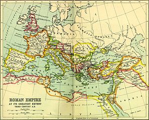
English: The Roman Empire at its greatest extent |
| Source |
This map of the Roman Empire was scanned from pages 16 & 17 of the 1907 Atlas of Ancient and Classical Geography in the Everyman Library, published by J.M. Dent & Sons Ltd. and is, by Canadian and US copyright law, in the public domain. It can be found for educational purposes in different universities and libraries, for instance, http://people.ucalgary.ca/~vandersp/Courses/maps/basicmap.html |
| Author |
Licensing
|
This is a faithful photographic reproduction of a two-dimensional, public domain work of art. The work of art itself is in the public domain for the following reason:
The official position taken by the Wikimedia Foundation is that "faithful reproductions of two-dimensional public domain works of art are public domain". This photographic reproduction is therefore also considered to be in the public domain in the United States. In other jurisdictions, re-use of this content may be restricted; see Reuse of PD-Art photographs for details. {{PD-Art}} template without license parameter: please specify why the underlying work is public domain in both the source country and the United States
(Usage: {{PD-Art|1=|deathyear=''year of author's death''|country=''source country''}}, where parameter 1= can be PD-old-auto, PD-old-auto-expired, PD-old-auto-1996, PD-old-100 or similar. See Commons:Multi-license copyright tags for more information.) | ||||
Original upload log
Transferred from en.wikipedia to Commons using For the Common Good.
The original description page was here. All following user names refer to en.wikipedia.
| Date/Time | Dimensions | User | Comment |
|---|---|---|---|
| 20:24, 5 July 2010 | 1,166 × 942 (375,960 bytes) | w:en:Beao (talk | contribs) | |
| 12:02, 23 March 2010 | 1,200 × 980 (321,311 bytes) | w:en:Aregakn (talk | contribs) | "The roman Empire at it's greatest extent" This map of the Roman Empire was scanned from pages 16 & 17 of a 1925 reprint of the 1907 Atlas of Ancient and Classical Geography in the Everyman Library, published by J.M. Dent & Sons Ltd. and is, by Canadian |
File history
Click on a date/time to view the file as it appeared at that time.
| Date/Time | Thumbnail | Dimensions | User | Comment | |
|---|---|---|---|---|---|
| current | 03:47, 3 April 2015 | | 1,166 × 942 (367 KB) | OgreBot | (BOT): Reverting to most recent version before archival |
| 03:47, 3 April 2015 |  | 1,200 × 980 (314 KB) | OgreBot | (BOT): Uploading old version of file from en.wikipedia; originally uploaded on 2010-03-23 12:02:42 by Aregakn | |
| 15:41, 31 March 2015 |  | 1,166 × 942 (367 KB) | Toxwiki96 | Transferred from en.wikipedia: see original upload log above |
File usage
The following 7 pages use this file:
Global file usage
The following other wikis use this file:
- Usage on it.wikibooks.org
- Usage on ko.wikipedia.org