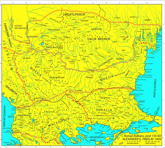
File:Roman Empire Map AlexanderFindlay1849.png
Appearance

Size of this preview: 668 × 599 pixels. Other resolutions: 268 × 240 pixels | 535 × 480 pixels | 856 × 768 pixels | 1,142 × 1,024 pixels | 2,038 × 1,828 pixels.
Original file (2,038 × 1,828 pixels, file size: 2 MB, MIME type: image/png)
File history
Click on a date/time to view the file as it appeared at that time.
| Date/Time | Thumbnail | Dimensions | User | Comment | |
|---|---|---|---|---|---|
| current | 15:44, 5 May 2019 |  | 2,038 × 1,828 (2 MB) | Julieta39 | Regiones Porolissensis et Napocaoensis cum salinae et aurum excavationes |
| 14:05, 24 September 2017 |  | 2,038 × 1,677 (1.9 MB) | Julieta39 | Orthographic correction (alutensis, not alupensis and superior, not superirior) | |
| 20:04, 5 November 2015 |  | 2,038 × 1,677 (1.9 MB) | Spiridon Ion Cepleanu | Easier colours for reading the place names | |
| 17:30, 25 February 2010 |  | 2,038 × 1,677 (1.8 MB) | Megistias | == {{int:filedesc}} == {{Information |Description=Map of the Roman provinces of Macedonia, Thracia, Illyricum, part of Pannonia Inferior, Moesia & Dacia. It is a reproduction of the 1849 Finley Map with Roman provincial borders (of about 150 AD) added to |
File usage
The following 6 pages use this file:
Global file usage
The following other wikis use this file:
- Usage on el.wikipedia.org
- Usage on fr.wikipedia.org
- Usage on la.wikipedia.org
- Usage on nl.wikipedia.org
- Usage on pt.wikipedia.org
- Usage on ro.wikipedia.org
- Usage on ru.wikipedia.org
- Usage on uk.wikipedia.org


