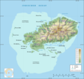
File:Rodrigues Zonenkarte de.png
Appearance

Size of this preview: 637 × 600 pixels. Other resolutions: 255 × 240 pixels | 510 × 480 pixels | 816 × 768 pixels | 1,088 × 1,024 pixels | 1,284 × 1,209 pixels.
Original file (1,284 × 1,209 pixels, file size: 559 KB, MIME type: image/png)
File history
Click on a date/time to view the file as it appeared at that time.
| Date/Time | Thumbnail | Dimensions | User | Comment | |
|---|---|---|---|---|---|
| current | 18:40, 18 January 2017 |  | 1,284 × 1,209 (559 KB) | Vuxi | - asd at bottom of map |
| 18:39, 18 January 2017 |  | 1,284 × 1,209 (559 KB) | Vuxi | - asd at bottom of map | |
| 14:15, 2 March 2010 |  | 1,284 × 1,209 (549 KB) | Vuxi | + Schriftzug | |
| 21:56, 1 March 2010 |  | 1,284 × 1,209 (545 KB) | Vuxi | einige Orte | |
| 21:36, 27 February 2010 |  | 1,284 × 1,209 (539 KB) | Vuxi | + Namen der Zonen + Orte - Berge | |
| 10:45, 26 February 2010 |  | 1,284 × 1,209 (524 KB) | Vuxi | {{Information |Description={{de|1=Zonenkarte der Insel Rodrigues}} |Source={{own}} |Author=Vuxi |Date= |Permission= |other_versions= }} topographic map:File:Rodrigues Island topographic map-de.svg, borders: [http://www.gov.mu/portal/sit |
File usage
The following page uses this file:
Global file usage
The following other wikis use this file:
- Usage on bn.wikipedia.org
- Usage on ceb.wikipedia.org
- Usage on de.wikipedia.org
- Usage on eo.wikipedia.org
- Usage on fr.wikipedia.org
- Usage on hu.wikipedia.org
- Usage on it.wikipedia.org
- Usage on ja.wikipedia.org
- Usage on nl.wikipedia.org
- Usage on nl.wiktionary.org
- Usage on pl.wikipedia.org
- Usage on ro.wikipedia.org
- Usage on tr.wikipedia.org
- Usage on uk.wikipedia.org
- Usage on vi.wikipedia.org
- Usage on www.wikidata.org
- Usage on yo.wikipedia.org
- Usage on zh.wikipedia.org
