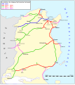
File:Reseau cft tunisie.svg
Appearance

Size of this PNG preview of this SVG file: 535 × 600 pixels. Other resolutions: 214 × 240 pixels | 428 × 480 pixels | 685 × 768 pixels | 914 × 1,024 pixels | 1,827 × 2,048 pixels | 877 × 983 pixels.
Original file (SVG file, nominally 877 × 983 pixels, file size: 263 KB)
File history
Click on a date/time to view the file as it appeared at that time.
| Date/Time | Thumbnail | Dimensions | User | Comment | |
|---|---|---|---|---|---|
| current | 08:16, 28 August 2018 |  | 877 × 983 (263 KB) | L0wside | Updated to reflect the current status (08/2018) of the Tunisian railway network |
| 19:26, 8 November 2007 |  | 822 × 922 (394 KB) | YassineMrabet | Corrections (carte + légende) | |
| 17:44, 8 November 2007 |  | 822 × 922 (405 KB) | YassineMrabet | dimensions | |
| 17:36, 8 November 2007 |  | 820 × 920 (409 KB) | YassineMrabet | Corrections | |
| 11:53, 8 November 2007 |  | 822 × 929 (403 KB) | YassineMrabet | Augmentation de l'opacité | |
| 11:48, 8 November 2007 |  | 822 × 929 (403 KB) | YassineMrabet | {{Information |Description={{fr|Évolution du réseau des chemins de fer Tunisiens entre 1894-1980. Vectorisation de l'image Image:Reseau cft.jpg, d'après la collection personnelle de Bertrand Bouret [http://profburp.com/].}} |Source=travail personn |
File usage
The following 5 pages use this file:
Global file usage
The following other wikis use this file:
- Usage on ar.wikipedia.org
- Usage on bn.wikivoyage.org
- Usage on de.wikipedia.org
- Usage on en.wikivoyage.org
- Usage on es.wikipedia.org
- Usage on fr.wikipedia.org
- Usage on it.wikipedia.org
- Usage on it.wikivoyage.org
- Usage on ru.wikipedia.org
- Usage on sv.wikipedia.org
- Usage on tr.wikipedia.org


