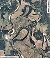
File:RedRiverMeandersArkansas1.jpg
Appearance

Size of this preview: 512 × 600 pixels. Other resolutions: 205 × 240 pixels | 410 × 480 pixels | 655 × 768 pixels | 874 × 1,024 pixels | 1,748 × 2,048 pixels | 3,055 × 3,580 pixels.
Original file (3,055 × 3,580 pixels, file size: 5.09 MB, MIME type: image/jpeg)
File history
Click on a date/time to view the file as it appeared at that time.
| Date/Time | Thumbnail | Dimensions | User | Comment | |
|---|---|---|---|---|---|
| current | 20:39, 27 May 2011 |  | 3,055 × 3,580 (5.09 MB) | Cristellaria | {{Information |Description ={{en|1=Aerial photograph of meandering course of Red River in Lafayette and Miller counties, Arkansas. It shows point bars, abandoned meander loops, ox bow lakes, and ridge and swale topography associated with the active cou |
File usage
The following 2 pages use this file:
Global file usage
The following other wikis use this file:
- Usage on af.wikipedia.org
- Usage on en.wikibooks.org

