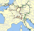
File:RamblesMap.png
Appearance
RamblesMap.png (597 × 538 pixels, file size: 58 KB, MIME type: image/png)
File history
Click on a date/time to view the file as it appeared at that time.
| Date/Time | Thumbnail | Dimensions | User | Comment | |
|---|---|---|---|---|---|
| current | 05:47, 16 December 2008 |  | 597 × 538 (58 KB) | Awadewit | adding arrows |
| 05:17, 10 November 2008 |  | 597 × 538 (56 KB) | Awadewit | adding arrows | |
| 15:02, 6 August 2008 |  | 597 × 538 (37 KB) | Ruhrfisch | Awadewit's map, I just fixed the color of the seas. | |
| 14:13, 6 August 2008 |  | 597 × 538 (37 KB) | Awadewit | {{Information |Description={{en|1=Map of Mary Shelley and her son Percy Florence Shelley's travels in 1840 and 1840-1840, taken from ''The Novels and Selected Works of Mary Shelley''. Vol. 8. Ed. Jeanne Moskal. London: William Pickering, 1996, pg. 58-59. |
File usage
No pages on the English Wikipedia use this file (pages on other projects are not listed).
Global file usage
The following other wikis use this file:
- Usage on de.wikipedia.org
- Usage on it.wikipedia.org


