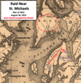
File:Raid Near St Michaels MD.png
Appearance

Size of this preview: 585 × 599 pixels. Other resolutions: 234 × 240 pixels | 469 × 480 pixels | 738 × 756 pixels.
Original file (738 × 756 pixels, file size: 1.26 MB, MIME type: image/png)
File history
Click on a date/time to view the file as it appeared at that time.
| Date/Time | Thumbnail | Dimensions | User | Comment | |
|---|---|---|---|---|---|
| current | 20:14, 1 December 2021 |  | 738 × 756 (1.26 MB) | TwoScarsUp | Uploaded a work by Fielding Lucas Jr. (1781-1854) with label, arrows, and circles added by TwoScarsUp from This is a crop of a Map of Maryland published in 1841, from the U.S. Library of Congress found [https://www.loc.gov/item/2002624038/ here]. Labels, circles, and arrows have been added by TwoScarsUp based on "History of Talbot County, Maryland, 1661-1861", Volume II, by Oswald Tilghman and Samuel A. Harrison, pages 173-175; and "The Chesapeake Campaigns 1813-15" by Scott S. Sheads, p.49-5... |
File usage
The following page uses this file:
