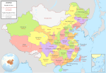
File:ROC PRC comparison eng.jpg
Appearance
ROC_PRC_comparison_eng.jpg (770 × 600 pixels, file size: 239 KB, MIME type: image/jpeg)
File history
Click on a date/time to view the file as it appeared at that time.
| Date/Time | Thumbnail | Dimensions | User | Comment | |
|---|---|---|---|---|---|
| current | 19:48, 18 January 2015 |  | 770 × 600 (239 KB) | Wwbread | Part of Bhutan and Russia was Rep. China. It has been marked in this map but not painted white. Also marked Nanking and Peking by two bigger stars. |
| 14:03, 16 December 2006 |  | 770 × 600 (316 KB) | Electionworld | {{ew|en|Pryaltonian}} == Legend details == * Black dotted lines are political boundaries drawn by the ROC. The formal names of these political entities are in black text. * Red solid lines are political boundaries drawn by the [[P |
File usage
More than 100 pages use this file. The following list shows the first 100 pages that use this file only. A full list is available.
- Talk:2012 Beijing Hyundai International Youth Football Tournament
- Talk:Acer cordatum
- Talk:Actephila excelsa
- Talk:Ailurarctos
- Talk:Analong
- Talk:Aquapeziza
- Talk:Aristolochia thwaitesii
- Talk:Assassination of Juma Tayir
- Talk:Beijing–Datong Expressway
- Talk:Black-faced spoonbill
- Talk:Borohoro Mountains
- Talk:Camp Holcomb
- Talk:China National Highway 324
- Talk:Chinese Soviet Republic
- Talk:Chinese constellations
- Talk:Chinese false-eyed turtle
- Talk:Chinese paddlefish
- Talk:Chinese penduline tit
- Talk:Chinese star maps
- Talk:Chinese thrush
- Talk:Creatonotos gangis
- Talk:Cypripedium macranthos
- Talk:Daohugoupterus
- Talk:Daurian ground squirrel
- Talk:Daurian starling
- Talk:Dinghao Market
- Talk:Doahuqou Formation
- Talk:Eleutherococcus senticosus
- Talk:Fenghuangopterus
- Talk:Five Lotus Spring
- Talk:Guo Zhongmin
- Talk:Hailong Market
- Talk:Hamamelis mollis
- Talk:Heishansaurus
- Talk:Jehol Biota
- Talk:Jianianhualong
- Talk:Jiufotang Formation
- Talk:John G. Kerr Refuge for the Insane
- Talk:Kemao Market
- Talk:Lanshan (Gansu)
- Talk:Linhai station
- Talk:List of Chinese star names
- Talk:List of Chinese teas
- Talk:Minggangia
- Talk:Mirusavis
- Talk:Mofu Point
- Talk:Morina nepalensis
- Talk:Mutianyu
- Talk:Nanyang Basin
- Talk:Nectocaris
- Talk:North Linkor Road
- Talk:Nothotsuga
- Talk:Paleobiota of the Yixian Formation
- Talk:Parama China kingdom
- Talk:Philippen's striped turtle
- Talk:Pingxing Pass
- Talk:Platostoma palustre
- Talk:Pomatosace
- Talk:Premna puberula
- Talk:Prostitution in Tibet
- Talk:Prunus mugus
- Talk:Pteroceltis tatarinowii
- Talk:Qabiao language
- Talk:Qingdao
- Talk:Reed parrotbill
- Talk:Sanxi, Jingde County
- Talk:Shandong Yinfeng Life Science Research Institute
- Talk:Shanxia
- Talk:Sinankylosaurus
- Talk:Sino-Indian War
- Talk:Sinospelaeobdella
- Talk:Skywalker hoolock gibbon
- Talk:Snakehead (gang)
- Talk:Social Axioms Survey
- Talk:Spotted thicklip loach
- Talk:Stegosaurides
- Talk:Tianchisaurus
- Talk:Tiaojishan Formation
- Talk:Trams in Shanghai (1908–1975)
- Talk:Trolleybuses in Jinan
- Talk:Trolleybuses in Shanghai
- Talk:Wan Chai Cargo Handling Basin
- Talk:Wu (state)
- Talk:Wuji County
- Talk:Wulong bohaiensis
- Talk:Wuzi Xueyuan Lu station
- Talk:Xi'an–Pingliang railway
- Talk:Yecheng walnut
- Talk:Yixian Formation
- Talk:Yunnan box turtle
- Talk:Zhejiangosaurus
- Talk:Zhuliangomyces
- Talk:Ziliujing Formation
- User:Pryaltonian
- User talk:Nlu/archive34
- Wikipedia talk:WikiProject China/Cartography
- File talk:ROC PRC comparison eng.jpg
- File talk:Zhengzhou location.png
- Template:WikiProject China
- Template:WikiProject China/sandbox
View more links to this file.
Global file usage
The following other wikis use this file:
- Usage on eo.wikipedia.org
- Usage on fr.wikipedia.org
- Usage on gan.wikipedia.org
- Usage on it.wikipedia.org
- Usage on ko.wikipedia.org
- Usage on nl.wikipedia.org
- Usage on pam.wikipedia.org
- Usage on ru.wikipedia.org
- Usage on vi.wikipedia.org
- Usage on zh.wikipedia.org


