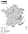
File:Réseaux de trolleybus en France.png
Appearance

Size of this preview: 462 × 599 pixels. Other resolutions: 185 × 240 pixels | 370 × 480 pixels | 592 × 768 pixels | 790 × 1,024 pixels | 2,221 × 2,879 pixels.
Original file (2,221 × 2,879 pixels, file size: 530 KB, MIME type: image/png)
File history
Click on a date/time to view the file as it appeared at that time.
| Date/Time | Thumbnail | Dimensions | User | Comment | |
|---|---|---|---|---|---|
| current | 17:08, 18 April 2018 |  | 2,221 × 2,879 (530 KB) | Chumwa | {{Information |Description= *{{de|Karte der O-Busbetriebe in Frankreich und in den ehemaligen Territorien unter französischer Verwaltung}} *{{en|Map of the trolleybus systems in France and in the former territories under Frech administration}} *{{fr|Carte des réseaux de trolleybus en France métropolitaine et dans le anciens territoires sous adminstration française}} |Source={{Own}} using the information from Georges Muller: ''Les trolleybus français en France et dans le Monde''. Madrid 2017 (... |
File usage
The following page uses this file:
Global file usage
The following other wikis use this file:
- Usage on de.wikipedia.org
- Usage on fr.wikipedia.org


