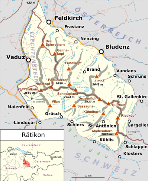
File:Rätikon map.png
Appearance

Size of this preview: 490 × 599 pixels. Other resolutions: 196 × 240 pixels | 392 × 480 pixels | 628 × 768 pixels | 837 × 1,024 pixels | 1,675 × 2,048 pixels | 3,154 × 3,857 pixels.
Original file (3,154 × 3,857 pixels, file size: 2.71 MB, MIME type: image/png)
File history
Click on a date/time to view the file as it appeared at that time.
| Date/Time | Thumbnail | Dimensions | User | Comment | |
|---|---|---|---|---|---|
| current | 16:07, 23 October 2017 |  | 3,154 × 3,857 (2.71 MB) | Pechristener | neutralere Locationmap |
| 23:39, 18 March 2015 |  | 3,364 × 4,114 (2.99 MB) | Pechristener | St. Gallenkirch hinzu / Panüeler hinzu / einige Höhenangaben hinzu | |
| 19:07, 17 March 2015 |  | 3,364 × 4,114 (2.93 MB) | Pechristener | {{Information |Description={{de|1=Lagekarte des de:Rätikon}} |Source ={{own}} Map was created using: *[http://www.openstreetmap.org/ Open Street Map] *Switzerland location map.svg for location ma... |
File usage
The following page uses this file:
Global file usage
The following other wikis use this file:
- Usage on als.wikipedia.org
- Usage on de.wikipedia.org
- Zimba
- Rätikon
- Schesaplana
- Panüeler Kopf
- Sulzfluh
- Totalphütte
- Alvier (Fluss)
- Scheienfluh
- Carschinahütte
- Liste der Gebirgsgruppen in den Ostalpen (nach AVE)
- Benutzer Diskussion:Pechristener/Archiv/1
- Gänglesee
- Vorlage:Positionskarte Rätikon
- Wikipedia:Kartenwerkstatt/Archiv/Zurückgewiesene und zurückgestellte Aufträge 2016
- Partnunsee
- Valser Bach (Taschinasbach)
- Girenspitz (Schuders)
- Galina-Gruppe
- Usage on de.wikivoyage.org
- Usage on it.wikipedia.org
- Usage on it.wikivoyage.org
- Usage on no.wikipedia.org
- Usage on ru.wikipedia.org
- Usage on sv.wikipedia.org
- Usage on uk.wikipedia.org
- Usage on www.wikidata.org
