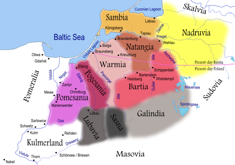
File:Prussian clans 13th century.png
Appearance

Size of this preview: 800 × 564 pixels. Other resolutions: 320 × 225 pixels | 640 × 451 pixels | 900 × 634 pixels.
Original file (900 × 634 pixels, file size: 353 KB, MIME type: image/png)
File history
Click on a date/time to view the file as it appeared at that time.
| Date/Time | Thumbnail | Dimensions | User | Comment | |
|---|---|---|---|---|---|
| current | 20:38, 6 April 2008 |  | 900 × 634 (353 KB) | Renata3 | resolution |
| 20:35, 6 April 2008 |  | 529 × 372 (159 KB) | Renata3 | masovia | |
| 22:55, 15 July 2007 |  | 991 × 713 (399 KB) | Renata3 | change colors and name for Sasna | |
| 18:34, 14 July 2007 |  | 1,012 × 728 (412 KB) | Renata3 | er... reduce size | |
| 18:31, 14 July 2007 |  | 2,029 × 1,455 (1.08 MB) | Renata3 | add more river names, insculde Sassen | |
| 00:43, 11 June 2007 |  | 989 × 722 (387 KB) | Renata3 | {{Information |Description=Map of Prussian clans during the 13th century |Source=Self-made using Inkscape |Date=2007-07-10 |Author= Renata3 }} For background I used: Image:LithuaniaPhysicalMap-Clean.svg by user:Knutux. Sources |
File usage
The following 28 pages use this file:
- Bartians
- Battle of Krücken
- Battle of Lubawa
- Battle of Pagastin
- Battle of Pokarwis
- Christian of Oliva
- Diwanus
- Galindians
- Germanisation of Prussia
- Kaliningrad
- Konrad I of Masovia
- List of tribes and states in Belarus, Russia and Ukraine
- Nadruvians
- Natangians
- Old Prussians
- Pogesanians
- Pomesanians
- Prussia (region)
- Prussian Crusade
- Prussian uprisings
- Sambians
- Sasna
- Siege of Bartenstein
- Siege of Königsberg
- Warmians
- User:Falcaorib/Germany and Prussia
- User:Hooj99/sandbox
- User:Kazkaskazkasako/Books/History
Global file usage
The following other wikis use this file:
- Usage on an.wikipedia.org
- Usage on ar.wikipedia.org
- Usage on bat-smg.wikipedia.org
- Usage on ba.wikipedia.org
- Usage on be-tarask.wikipedia.org
- Usage on be.wikipedia.org
- Usage on bg.wikipedia.org
- Usage on ca.wikipedia.org
- Usage on ce.wikipedia.org
- Usage on csb.wikipedia.org
- Usage on cs.wikipedia.org
- Usage on da.wikipedia.org
- Usage on dsb.wikipedia.org
- Usage on el.wikipedia.org
- Usage on en.wiktionary.org
- Usage on eo.wikipedia.org
- Usage on es.wikipedia.org
- Usage on et.wikipedia.org
View more global usage of this file.

