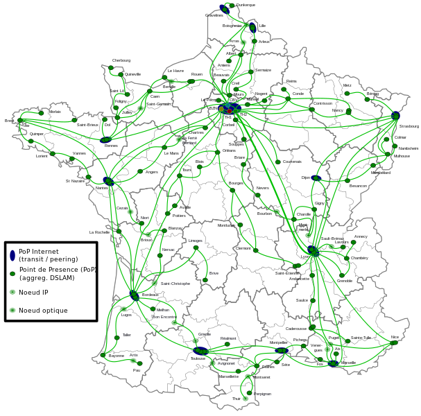
File:Proxad FR.svg
Appearance

Size of this PNG preview of this SVG file: 607 × 600 pixels. Other resolutions: 243 × 240 pixels | 486 × 480 pixels | 777 × 768 pixels | 1,036 × 1,024 pixels | 2,073 × 2,048 pixels | 2,700 × 2,668 pixels.
Original file (SVG file, nominally 2,700 × 2,668 pixels, file size: 1.35 MB)
File history
Click on a date/time to view the file as it appeared at that time.
| Date/Time | Thumbnail | Dimensions | User | Comment | |
|---|---|---|---|---|---|
| current | 13:29, 9 June 2015 |  | 2,700 × 2,668 (1.35 MB) | Pic-Sou | correcting cities names, adding a lacking DSLG POP |
| 05:44, 10 May 2010 |  | 2,700 × 2,668 (1.36 MB) | Ludovic.ferre | Adding peering and transit sites. | |
| 07:07, 9 May 2010 |  | 2,700 × 2,668 (1.33 MB) | Ludovic.ferre | Changed PoP size and added legend. Also changed main color theme. | |
| 22:22, 3 May 2010 |  | 2,700 × 2,668 (1.27 MB) | Ludovic.ferre | Too many to list here ;). | |
| 15:42, 2 May 2010 |  | 2,700 × 2,668 (547 KB) | Ludovic.ferre | {{Information |Description={{fr|1=Une carte de France avec les implantations réseaux (PoP, point de présence) de Iliad/Free. A noter que les vus sont au niveau de la couche TCP/IP (la couche optique étant transparente). Aussi l'Ilde de France est gran |
File usage
The following page uses this file:
Global file usage
The following other wikis use this file:
- Usage on eo.wikipedia.org
- Usage on fr.wikipedia.org
