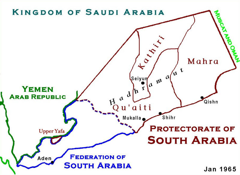
File:ProtectorateOfSouthArabiaMap.jpg
Appearance

Size of this preview: 800 × 584 pixels. Other resolutions: 320 × 234 pixels | 640 × 467 pixels | 912 × 666 pixels.
Original file (912 × 666 pixels, file size: 273 KB, MIME type: image/jpeg)
File history
Click on a date/time to view the file as it appeared at that time.
| Date/Time | Thumbnail | Dimensions | User | Comment | |
|---|---|---|---|---|---|
| current | 02:12, 18 January 2010 |  | 912 × 666 (273 KB) | Anonimosanhueza | borders removed |
| 01:14, 28 November 2008 |  | 928 × 682 (284 KB) | Nickpo | {{svg|map}} {{ew|en|AjaxSmack}} == Summary == Based on Work of US Government agency == Licensing == {{PD-USGov}} Category:Maps of Yemen Category:Qu'aiti State of Shihr and Mukalla Category:Federation of South Arabia [[Category:Kathiri State | |
| 22:56, 17 December 2006 |  | 928 × 682 (118 KB) | Electionworld | {{ew|en|AjaxSmack}} == Summary == Based on Work of US Government agency == Licensing == {{PD-USGov}} |
File usage
The following 5 pages use this file:
Global file usage
The following other wikis use this file:
- Usage on ar.wikipedia.org
- Usage on be.wikipedia.org
- Usage on bn.wikipedia.org
- Usage on ca.wikipedia.org
- Usage on cs.wikipedia.org
- Usage on de.wikipedia.org
- Usage on es.wikipedia.org
- Usage on fr.wikipedia.org
- Usage on fr.wiktionary.org
- Usage on hr.wikipedia.org
- Usage on id.wikipedia.org
- Usage on it.wikipedia.org
- Usage on ja.wikipedia.org
- Usage on lt.wikipedia.org
- Usage on mk.wikipedia.org
- Usage on no.wikipedia.org
- Usage on pl.wikipedia.org
- Usage on pnb.wikipedia.org
- Usage on pt.wikipedia.org
- Usage on ru.wikipedia.org
View more global usage of this file.


