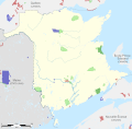
File:Protected areas of New Brunswick map-blank.svg

Original file (SVG file, nominally 2,237 × 2,199 pixels, file size: 2.77 MB)
| This is a file from the Wikimedia Commons. Information from its description page there is shown below. Commons is a freely licensed media file repository. You can help. |
Summary
| DescriptionProtected areas of New Brunswick map-blank.svg |
English: Blank map of protected areas of New Brunswick, Canada. Each area can be selected and colored separately. It have an unique ID, easi to find (for example, Ctrl+F in Inkscape). See the area lists below. Legend:
Geographic limits of the map:
Français : Carte muette des zones protégées du Nouveau-Brunswick, Canada. Chaque zone peut être sélectionnée et colorée séparément. Elles ont toutes un identifiant unique, facile à trouver (par exemple, Ctrl+F dans Inkscape). Voir les listes des zones ci-dessous. Légende :
Limites géographiques de la carte :
|
||
| Date | |||
| Source |
Own work. English:
GéoGratis Données-cadres nationales de l'Atlas du Canada à l'échelle de 1/1 000 000, aires protégées]Atlas of Canada 1,000,000 National Frameworks Data, Protected Areas Français : GéoGratis Données-cadres nationales de l'Atlas du Canada à l'échelle de 1/1 000 000, aires protégées]Atlas of Canada 1,000,000 National Frameworks Data, Protected Areas |
||
| Author | Sémhur (talk) | ||
| Other versions | |||
| Attribution (required by the license) InfoField | © Sémhur / Wikimedia Commons / | ||
InfoField | © Sémhur / Wikimedia Commons | ||
| SVG InfoField | |||
| Graphic Lab InfoField |
|
| Camera location | 46° 24′ 00″ N, 66° 24′ 00″ W | View this and other nearby images on: OpenStreetMap |
|---|
Licensing
| Copyleft: This work of art is free; you can redistribute it and/or modify it according to terms of the Free Art License. You will find a specimen of this license on the Copyleft Attitude site as well as on other sites. http://artlibre.org/licence/lal/enFALFree Art Licensefalsetrue |
- You are free:
- to share – to copy, distribute and transmit the work
- to remix – to adapt the work
- Under the following conditions:
- attribution – You must give appropriate credit, provide a link to the license, and indicate if changes were made. You may do so in any reasonable manner, but not in any way that suggests the licensor endorses you or your use.
- share alike – If you remix, transform, or build upon the material, you must distribute your contributions under the same or compatible license as the original.
Lists
New Brunswick
- National parks
501800001_Fundy_National_Park
501800002_Kouchibouguac_National_Park
- Provincial parks
502000001_Campobello
502000002_Castalia
502000003_Escuminac
502000004_Grand_Lake
502000005_Hay_Island
502000006_L'Aboiteau
502000007_Lake_George
502000008_Lakeside
502000009_Lepreau_Falls
502000010_Les_Jardins_de_la_République
502000011_Mactaquac
502000012_Middle_Island
502000013_Mount_Carleton
502000014_Murray_Beach
502000015_New_River_Beach
502000016_Oak_Bay
502000017_Oak_Point
502000018_Parlee_Beach
502000019_Shippegan
502000020_Spednic_Lake
502000021_Sugarloaf
502000022_Sunbury-Oromocto
502000023_The_Anchorage
502000024_The_Enclosure
502000025_The_Rocks
502000026_Val_Comeau
502000027_Woolastook
502000028_Youghall_Beach
502000029_North_Lake
- Natural areas
502100001_Bay_du_Vin_Island
502100002_Black_River
502100003_Blue_Mountain
502100004_Caledonia_Gorge
502100005_Canaan_Bog
502100006_Canoose_Flowage
502100007_Cranberry_Lake
502100008_Freeze_Lakes
502100009_Glazier_Lake
502100010_Gover_Mountain
502100011_Grand_Lake_Meadows
502100012_Hovey_Hill
502100013_Jacquet_River_Gorge
502100014_Kennedy_Lakes
502100015_Little_Salmon_River
502100016_Little_Tomoowa_Lake
502100017_Loch_Alva
502100018_McCoy_Brook
502100019_McManus_Hill
502100020_Mount_Carleton
502100021_Mount_Elizabeth
502100022_Oak_Mountain
502100023_Phillipstown
502100024_Point_Wolfe_River_Gorge
502100025_South_Kedgwick_River
502100026_Spednic_Lake
502100027_St._Croix_River_Islands
502100028_Tabusintac
502100029_Wilson_Brook
- Marine area
503000001_Musquash
- Wildlife area
504000001_Portobello_Creek_National_Wildlife_Area
504000002_Tintamarre_National_Wildlife_Area
504000003_Fundy_Trail_Provincial_Park
Other territories
- Québec
QCAC006_Canton_Varin
QCAC012_Duchenier
QCAC025_Lac_Biencourt
QCAC034_Lac_du_Pain_de_Sucre
QCAC069_Riviere_Bonaventure
QCAC075_Riviere_de_l_Orient
QCAC079_Riviere_Escuminac
QCAC085_Riviere_Nouvelle
QCAC088_Riviere_Port-Daniel
QCAC096_Ruisseau_Baseley
QCAO576_Pointe_de_Paspebiac
QCAO721_Saint-Godefroi_Paspebiac
QCPN013_Lac-Temiscouata
QCRB002_Karst-de-Saint-Elzear
QCRE008_Charles-B.-Banville
- Maine
MA01_Allagash_Wilderness_Waterway
MA03_Aroostook_State_Park
MA04_Baxter_State_Park
MA08_Cobscook_Bay_State_Park
MA18_Fort_Kent_State_Historic_Site
MA26_Katahdin_Iron_Works
MA36_Penobscot_River_Corridor
MA38_Quoddy_Head_State_Park
MA42_Roque_Bluffs_State_Park
MA44_Shackford_Head_State_Park
MA45_Swan_Lake_State_Park
- Nova-Scotia
NSWA03_John_Lusby_National_Wildlife_Area
NSWI07_Cloud_Lake_Wilderness_Area
NSWI08_Economy_River_Wilderness_Area
NSWI22_Portapique_River_Wilderness_Area
NSWI26_Terence_Bay_Wilderness_Area
NSWI29_Tobeatic_Wilderness_Area
NSPP21_Cape_Chignecto_Provincial_Park
NSPP60_Long_Lake_Provincial_Park
Captions
Items portrayed in this file
depicts
23 November 2011
46°24'N, 66°24'W
File history
Click on a date/time to view the file as it appeared at that time.
| Date/Time | Thumbnail | Dimensions | User | Comment | |
|---|---|---|---|---|---|
| current | 11:51, 23 May 2014 |  | 2,237 × 2,199 (2.77 MB) | Sémhur | Valid SVG |
| 18:34, 29 November 2011 |  | 2,237 × 2,199 (2.77 MB) | Sémhur | les parcs du Lac-Témiscouata (Québec) et Baxter (Maine) sont des « parcs provinciaux ». | |
| 22:49, 23 November 2011 |  | 2,237 × 2,199 (2.77 MB) | Sémhur | == {{int:filedesc}} == {{Information |Description={{Multilingual description |en=Blank map of protected areas of New Brunswick, Canada.<br> Each area can be selected and colored separately. It have an unique ID, easi to find (for exa |
File usage
The following 2 pages use this file:
Global file usage
The following other wikis use this file:
- Usage on fr.wikipedia.org
Metadata
This file contains additional information, probably added from the digital camera or scanner used to create or digitize it.
If the file has been modified from its original state, some details may not fully reflect the modified file.
| Short title | Carte du Nouveau-Brunswick |
|---|---|
| Width | 2237.28 |
| Height | 2198.9099 |
