File:PrairiePotholeRegionMap.gif
Appearance
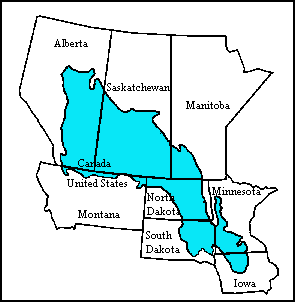
PrairiePotholeRegionMap.gif (295 × 302 pixels, file size: 5 KB, MIME type: image/gif)
File history
Click on a date/time to view the file as it appeared at that time.
| Date/Time | Thumbnail | Dimensions | User | Comment | |
|---|---|---|---|---|---|
| current | 01:53, 6 April 2008 |  | 295 × 302 (5 KB) | File Upload Bot (Magnus Manske) | {{BotMoveToCommons|en.wikipedia}} {{Information |Description={{en|Map of the Prairie Pothole Region of North America. From the US Geological Survey, http://www.npwrc.usgs.gov/resource/wetlands/pothole/prairie.htm}} |Source=Transferred from [http://en.wik |
File usage
The following page uses this file:
Global file usage
The following other wikis use this file:
- Usage on af.wikipedia.org
- Usage on de.wikipedia.org
- Usage on nds.wikipedia.org
- Usage on www.wikidata.org


