
File:Portugues map of India, 1630.jpg

Size of this preview: 554 × 599 pixels. Other resolutions: 222 × 240 pixels | 444 × 480 pixels | 710 × 768 pixels | 947 × 1,024 pixels | 1,893 × 2,047 pixels.
Original file (1,893 × 2,047 pixels, file size: 488 KB, MIME type: image/jpeg)
| This is a file from the Wikimedia Commons. Information from its description page there is shown below. Commons is a freely licensed media file repository. You can help. |
Summary
| Description |
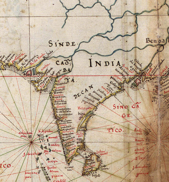
English: Detail of India, from a 1630 Portuguese map of Asia, entitled Taboas geraes de toda a navegação, divididas e emendadas por Dom Ieronimo de Attayde com todos os portos principaes das conquistas de Portugal delineadas por Ioão Teixeira cosmographo de Sua Magestade, anno de 1630 (General tables of all the navigation, divided and corrected by D. Jeronimo de Ataide, with all the ports and conquests of Portugal delineated by Joao Teixeira, cosmographer of His Majesty, Year 1630" |
| Source | Taboas geraes de toda a navegação |
| Author | Jeronimo de Ataide, João Teixeira |
Licensing
|
This is a faithful photographic reproduction of a two-dimensional, public domain work of art. The work of art itself is in the public domain for the following reason:
The official position taken by the Wikimedia Foundation is that "faithful reproductions of two-dimensional public domain works of art are public domain". This photographic reproduction is therefore also considered to be in the public domain in the United States. In other jurisdictions, re-use of this content may be restricted; see Reuse of PD-Art photographs for details. {{PD-Art}} template without license parameter: please specify why the underlying work is public domain in both the source country and the United States
(Usage: {{PD-Art|1=|deathyear=''year of author's death''|country=''source country''}}, where parameter 1= can be PD-old-auto, PD-old-auto-expired, PD-old-auto-1996, PD-old-100 or similar. See Commons:Multi-license copyright tags for more information.) | ||||
File history
Click on a date/time to view the file as it appeared at that time.
| Date/Time | Thumbnail | Dimensions | User | Comment | |
|---|---|---|---|---|---|
| current | 08:17, 24 June 2010 | | 1,893 × 2,047 (488 KB) | Walrasiad | {{Information |Description={{en|1=Detail of India, from a 1630 Portuguese map of Asia, entitled Taboas geraes de toda a navegação, divididas e emendadas por Dom Ieronimo de Attayde com todos os portos principaes das conquistas de Portugal delineadas por |
File usage
The following page uses this file:
Global file usage
The following other wikis use this file:
- Usage on de.wikipedia.org
- Usage on it.wikipedia.org
- Usage on oc.wikipedia.org
- Usage on sq.wikipedia.org