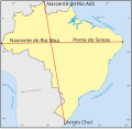
File:Pontos extremos do território Brasileiro.svg
Appearance

Size of this PNG preview of this SVG file: 619 × 599 pixels. Other resolutions: 248 × 240 pixels | 496 × 480 pixels | 793 × 768 pixels | 1,057 × 1,024 pixels | 2,115 × 2,048 pixels | 664 × 643 pixels.
Original file (SVG file, nominally 664 × 643 pixels, file size: 671 KB)
File history
Click on a date/time to view the file as it appeared at that time.
| Date/Time | Thumbnail | Dimensions | User | Comment | |
|---|---|---|---|---|---|
| current | 13:49, 20 September 2023 |  | 664 × 643 (671 KB) | Cataleirxs | File uploaded using svgtranslate tool (https://svgtranslate.toolforge.org/). Added translation for ca. |
| 21:25, 14 April 2016 |  | 664 × 643 (665 KB) | High source | Location dot black. | |
| 21:11, 14 April 2016 |  | 664 × 643 (675 KB) | High source | User created page with UploadWizard |
File usage
The following page uses this file:
Global file usage
The following other wikis use this file:
- Usage on ast.wikipedia.org
- Usage on ca.wikipedia.org
- Usage on es.wikipedia.org
- Usage on fr.wikipedia.org
- Usage on pt.wikipedia.org


