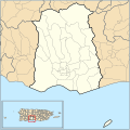
File:Ponce barrios map.svg
Appearance

Size of this PNG preview of this SVG file: 600 × 600 pixels. Other resolutions: 240 × 240 pixels | 480 × 480 pixels | 768 × 768 pixels | 1,024 × 1,024 pixels | 2,048 × 2,048 pixels | 765 × 765 pixels.
Original file (SVG file, nominally 765 × 765 pixels, file size: 303 KB)
File history
Click on a date/time to view the file as it appeared at that time.
| Date/Time | Thumbnail | Dimensions | User | Comment | |
|---|---|---|---|---|---|
| current | 17:12, 10 March 2010 |  | 765 × 765 (303 KB) | Kmusser | better border fix, bold border of Ponce, restore inset |
| 02:31, 9 March 2010 |  | 765 × 765 (315 KB) | Kmusser | delete sliver polygon | |
| 16:46, 8 March 2010 |  | 765 × 765 (295 KB) | Kmusser | == Summary == {{Information |Description= {{en|This is a locator map of the barrios of en:Ponce, Puerto Rico.}} |Source={{own}}. Data source: Census Bureau [http://www.census.gov/geo/www/cob/]. |Date=2010-03-08 |Author=Kmusser |Perm |
File usage
The following 2 pages use this file:
Global file usage
The following other wikis use this file:
- Usage on simple.wikipedia.org
