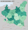
File:PolishRepublicAdminMap1939.png
Appearance

Size of this preview: 559 × 599 pixels. Other resolutions: 224 × 240 pixels | 448 × 480 pixels | 717 × 768 pixels | 956 × 1,024 pixels | 1,911 × 2,048 pixels | 4,000 × 4,286 pixels.
Original file (4,000 × 4,286 pixels, file size: 3.3 MB, MIME type: image/png)
File history
Click on a date/time to view the file as it appeared at that time.
| Date/Time | Thumbnail | Dimensions | User | Comment | |
|---|---|---|---|---|---|
| current | 14:11, 10 April 2024 |  | 4,000 × 4,286 (3.3 MB) | XrysD | Corrected border of Warsaw city for 1938 changes |
| 16:50, 4 February 2022 |  | 4,000 × 4,286 (3.28 MB) | XrysD | Typos: Śląnskie-->Śląskie, Bielsko Śląnskie--> Bielsko, Biała Małopolska-->Biała | |
| 10:29, 13 August 2017 |  | 4,000 × 4,283 (3.52 MB) | XrysD | Replaced entire colour scheme with one using WP recommended ColorBrewer system | |
| 15:25, 5 August 2017 |  | 4,000 × 4,283 (3.44 MB) | XrysD | Reverted to version as of 11:21, 23 July 2017 (UTC) - Original map colours are those published by Bartholomew UK (1990). As such they have been established as a valid and legible combination. They should not be replaced by other users personal subjecti... | |
| 14:49, 5 August 2017 |  | 4,000 × 4,283 (3.64 MB) | Poeticbent | adjusted background hue for readability, losslessly | |
| 11:21, 23 July 2017 |  | 4,000 × 4,283 (3.44 MB) | XrysD | Harmonisation with changes to original Polish language version | |
| 19:07, 16 July 2017 |  | 4,000 × 4,283 (3.43 MB) | XrysD | User created page with UploadWizard |
File usage
The following 4 pages use this file:
Global file usage
The following other wikis use this file:
- Usage on bn.wikipedia.org
- Usage on pt.wikipedia.org
- Usage on ru.wikipedia.org
