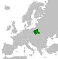
File:Poland 1918.png
Appearance

Size of this preview: 591 × 600 pixels. Other resolutions: 237 × 240 pixels | 473 × 480 pixels | 900 × 913 pixels.
Original file (900 × 913 pixels, file size: 102 KB, MIME type: image/png)
File history
Click on a date/time to view the file as it appeared at that time.
| Date/Time | Thumbnail | Dimensions | User | Comment | |
|---|---|---|---|---|---|
| current | 17:32, 12 June 2015 |  | 900 × 913 (102 KB) | Pogo91 | Właściwa granica Finlandii |
| 17:23, 12 June 2015 |  | 900 × 913 (102 KB) | Pogo91 | Granica wschodnia dodałem powiaty: Janowski, Radzyń, Bialski, Włodawski. Wzorowałem się na tej mapie: File:Krolpolskie1918kzo.png | |
| 14:43, 19 May 2015 |  | 900 × 913 (141 KB) | Pogo91 | The west border now is in a white color. | |
| 14:33, 15 January 2015 |  | 900 × 913 (103 KB) | Pogo91 | Broders are corrected according to File:OkupacjaKP1914-18.PNG. (This is still not final version). | |
| 15:27, 2 April 2014 |  | 900 × 913 (102 KB) | Pogo91 | I have corrected east polish border. | |
| 14:49, 15 March 2014 |  | 900 × 913 (102 KB) | Pogo91 | I have corrected african borders. Poprawiłem granice afrykańskie. | |
| 17:21, 15 February 2014 |  | 900 × 913 (140 KB) | Pogo91 | User created page with UploadWizard |
File usage
The following 2 pages use this file:
Global file usage
The following other wikis use this file:
- Usage on az.wikipedia.org
- Usage on cs.wikipedia.org
- Usage on de.wikipedia.org
- Usage on es.wikipedia.org
- Usage on fa.wikipedia.org
- Usage on fi.wikipedia.org
- Usage on fr.wikipedia.org
- Usage on he.wikipedia.org
- Usage on it.wikipedia.org
- Usage on ja.wikipedia.org
- Usage on ko.wikipedia.org
- Usage on mk.wikipedia.org
- Usage on ms.wikipedia.org
- Usage on nl.wikipedia.org
- Usage on pl.wikipedia.org
- Usage on pt.wikipedia.org
- Usage on ru.wikipedia.org
- Usage on simple.wikipedia.org
- Usage on sr.wikipedia.org
- Usage on th.wikipedia.org
- Usage on uk.wikipedia.org
- Usage on vi.wikipedia.org
- Usage on zh.wikipedia.org
