Jump to content

File:Plan de Paris vers 1300-1330 - ALPAGE.svg

Page contents not supported in other languages.
This is a file from the Wikimedia Commons
From Wikipedia, the free encyclopedia

Original file (SVG file, nominally 2,430 × 2,506 pixels, file size: 443 KB)

Summary

Title
Paris vers 1300-1330
Description
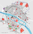
English: Map of Paris about 1300-1330.
Français : Plan de Paris vers 1300-1330. Les rues et le bâti rendent compte de l’état en 1300, son étendue a été déterminée au moyen des livres de la taille. Pour les édifices royaux et communaux, l’état correspond plutôt à 1330. Il est à remarquer que les densités de population sont très inégales dans les différents quartiers de la capitale, ce dont la carte ne témoigne pas. Document réalisé d’après Leuridan (J.), Mallet (J.-A.), Plan restitué de Paris en 1387, Paris, CNRS Éditions, 1999 [1e édition 1991] ; Lenoir (A.), Plan de La ville de Paris sous Philippe-le-Bel dressé d’après le travail de H. Géraud, [publié en annexe à] Géraud (H.), éd., Paris sous Philippe-le-Bel d'après des documents originaux et notamment d'après un manuscrit contenant le rôle de la taille imposée sur les habitants de Paris en 1292, Paris, Impr. de Crapelet, 1837, XVI-638 p. (Collection de documents inédits sur l'histoire de France ; première série, Histoire politique).
Map legend
 
Built environment Espaces bâtis
 
Fields, farming, vacant lot Champs, cultures, terrains vagues
 
Religious buildings Edifices religieux
 
Religious buildings under construction   Edifices religieux en construction
 
Colleges Collèges
 
Hôtels particuliers Hôtels particuliers
 
Royal and municipal buildings Edifices royaux et communaux
 
Hospitals Hôpitaux
+ + +
 
Cemeteries Cimetières
 
Jewish cemeteries Cimetières juifs
 
Markets Halles
Date
Source Analyse diachronique de l'espace urbain Parisien: Home · Info · Image
Creator
Caroline Bourlet (IRHT), Nicolas Thomas (INRAP-LAMOP), Cédric Roms (INRAP)
Georeferencing Georeference the map in Wikimaps Warper If inappropriate please set warp_status = skip to hide.


Licensing

w:en:Creative Commons
attribution
This file is licensed under the Creative Commons Attribution 2.0 France license.
You are free:
  • to share – to copy, distribute and transmit the work
  • to remix – to adapt the work
Under the following conditions:
  • attribution – You must give appropriate credit, provide a link to the license, and indicate if changes were made. You may do so in any reasonable manner, but not in any way that suggests the licensor endorses you or your use.
This file, which was originally posted to http://alpage.huma-num.fr/fr/ressources, was reviewed on 21 February 2015 by reviewer Thibaut120094, who confirmed that it was available there under the stated license on that date.

Captions

Add a one-line explanation of what this file represents

Items portrayed in this file

depicts

image/svg+xml

File history

Click on a date/time to view the file as it appeared at that time.

Date/TimeThumbnailDimensionsUserComment
current02:41, 22 February 2015Thumbnail for version as of 02:41, 22 February 20152,430 × 2,506 (443 KB)Paris 16 
09:42, 20 February 2015Thumbnail for version as of 09:42, 20 February 20152,430 × 2,506 (431 KB)Paris 16

The following page uses this file:

Global file usage

The following other wikis use this file:

Metadata