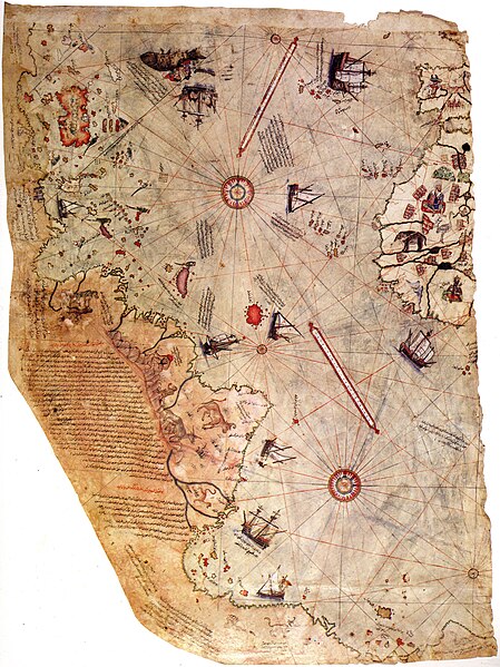
File:Piri reis world map 01.jpg
Appearance

Size of this preview: 449 × 599 pixels. Other resolutions: 180 × 240 pixels | 360 × 480 pixels | 576 × 768 pixels | 768 × 1,024 pixels | 1,964 × 2,619 pixels.
Original file (1,964 × 2,619 pixels, file size: 7.08 MB, MIME type: image/jpeg)
| This image appeared on Wikipedia's Main Page in the Did you know? column on 27 February 2008 (see archives). |
File history
Click on a date/time to view the file as it appeared at that time.
| Date/Time | Thumbnail | Dimensions | User | Comment | |
|---|---|---|---|---|---|
| current | 23:16, 17 July 2017 |  | 1,964 × 2,619 (7.08 MB) | Earthsound | Reverted to version as of 04:00, 17 August 2012 (UTC) The higher resolution images that replaced this are horribly pixelated and have been created by enlarging a much smaller copy. |
| 12:45, 13 November 2016 |  | 3,387 × 4,807 (2.16 MB) | Alonso de Mendoza | color | |
| 13:19, 5 March 2016 |  | 3,387 × 4,807 (1.6 MB) | ديفيد عادل وهبة خليل 2 | Cropped 5 % horizontally and 5 % vertically using CropTool with precise mode. | |
| 10:37, 23 November 2014 |  | 3,564 × 5,040 (1,019 KB) | Ratzer | higher Resolution 3564 x 5040, source http://www.erisi.com/gelisim/harita/pri/piri_dunya.jpg | |
| 04:00, 17 August 2012 |  | 1,964 × 2,619 (7.08 MB) | FunkMonk | ||
| 02:45, 10 February 2008 |  | 2,000 × 2,753 (2.27 MB) | FunkMonk | {{Information |Description= |Source= |Date= |Author= |Permission= |other_versions= }} | |
| 14:45, 13 September 2006 |  | 829 × 1,087 (205 KB) | InfoCan | rotated previous version of map so North is up. | |
| 07:09, 29 September 2005 |  | 1,087 × 829 (338 KB) | CristianChirita | Piri Reis World Map |
File usage
The following 27 pages use this file:
- Early world maps
- Geography and cartography in the medieval Islamic world
- Graham Hancock
- History of cartography
- History of the Ottoman Empire
- List of cartographers
- Ottoman Navy
- Piri Reis
- Piri Reis map
- Science in the medieval Islamic world
- Terra Australis
- Vinland
- User:5faizan/Islam
- User:Dronebogus/Basement
- User:Musaabdulrashid
- User:Musaabdulrashid/sandbox2
- Wikipedia:Featured picture candidates/March-2008
- Wikipedia:Featured picture candidates/October-2023
- Wikipedia:Featured picture candidates/Piri Reis map
- Wikipedia:Featured picture candidates/Piri reis world map 01.jpg
- Wikipedia:Graphics Lab/Illustration workshop/Archive/Aug 2023
- Wikipedia:Recent additions/2008/February
- Portal:History of science
- Portal:Islam/DYK
- Portal:Islam/DYK/24
- Portal:Maps
- Portal:Turkey/Did you know/Archive
Global file usage
The following other wikis use this file:
- Usage on ar.wikipedia.org
- جزر الأنتيل
- قائمة اختراعات المسلمين في العصور الوسطى
- بوابة:الدولة العثمانية/صورة
- ويكيبيديا:صور مختارة/رسومات وجداول وخرائط/خرائط
- بيري ريس
- خريطة بيري ريس
- ويكيبيديا:ترشيحات الصور المختارة/خريطة أحمد محيي الدين امريكا
- ويكيبيديا:صورة اليوم المختارة/مايو 2016
- قالب:صورة اليوم المختارة/2016-05-23
- بوابة:الدولة العثمانية/صورة مختارة/19
- ويكيبيديا:صورة اليوم المختارة/أغسطس 2017
- قالب:صورة اليوم المختارة/2017-08-22
- ويكيبيديا:صورة اليوم المختارة/يوليو 2019
- قالب:صورة اليوم المختارة/2019-07-23
- كتاب الملاحة
- ويكيبيديا:صورة اليوم المختارة/يناير 2022
- قالب:صورة اليوم المختارة/2022-01-15
- Usage on azb.wikipedia.org
- Usage on az.wikipedia.org
- Usage on bg.wikipedia.org
- Usage on bn.wikipedia.org
- Usage on ca.wikipedia.org
- Usage on cbk-zam.wikipedia.org
- Usage on ckb.wikipedia.org
- Usage on cs.wikipedia.org
- Usage on da.wikipedia.org
- Usage on de.wikipedia.org
View more global usage of this file.


