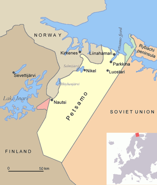
File:Petsamo.png
Appearance

Size of this preview: 507 × 599 pixels. Other resolutions: 203 × 240 pixels | 406 × 480 pixels.
Original file (800 × 945 pixels, file size: 30 KB, MIME type: image/png)
File history
Click on a date/time to view the file as it appeared at that time.
| Date/Time | Thumbnail | Dimensions | User | Comment | |
|---|---|---|---|---|---|
| current | 19:08, 17 June 2015 |  | 800 × 945 (30 KB) | Hohum | Clearer |
| 17:48, 1 August 2005 |  | 800 × 945 (70 KB) | Jniemenmaa | Map of Petsamo area in northern Finland/Soviet Union/Russia. The green area is the Finnish part of the Rybachi peninsula which was ceded to the Soviet Union after the Winter War. The Red area is the Jäniskoksi area ceded to the SU some years after the C |
File usage
The following 15 pages use this file:
- August Mors
- Central European Time
- Friedrich-Wilhelm Strakeljahn
- Heinrich Bartels
- Jakob Norz
- Jäniskoski-Niskakoski territory
- Norway–Russia border
- Operation EF (1941)
- Pechengsky District
- Rudi Linz
- Rybachy Peninsula
- Walter Schuck
- User:Falcaorib/Russia and Soviet Union
- User:Falcaorib/Sweden and Finland
- User:Jniemenmaa/images
Global file usage
The following other wikis use this file:
- Usage on ar.wikipedia.org
- Usage on ba.wikipedia.org
- Usage on ca.wikipedia.org
- Usage on cs.wikipedia.org
- Usage on da.wikipedia.org
- Usage on de.wikipedia.org
- Usage on eo.wikipedia.org
- Usage on es.wikipedia.org
- Usage on eu.wikipedia.org
- Usage on fi.wikipedia.org
- Usage on fr.wikipedia.org
- Usage on gl.wikipedia.org
- Usage on hu.wikipedia.org
- Usage on it.wikipedia.org
- Usage on nl.wikipedia.org
- Usage on nn.wikipedia.org
- Usage on no.wikipedia.org
- Usage on pl.wikipedia.org
- Usage on pt.wikipedia.org
View more global usage of this file.


