File:Penncolony.png
Appearance

Size of this preview: 667 × 599 pixels. Other resolutions: 267 × 240 pixels | 534 × 480 pixels | 700 × 629 pixels.
Original file (700 × 629 pixels, file size: 210 KB, MIME type: image/png)
File history
Click on a date/time to view the file as it appeared at that time.
| Date/Time | Thumbnail | Dimensions | User | Comment | |
|---|---|---|---|---|---|
| current | 14:54, 13 March 2007 |  | 700 × 629 (210 KB) | Kmusser | Added dispute with Virginia. |
| 20:00, 1 November 2006 |  | 500 × 449 (37 KB) | Kmusser | ||
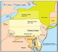
| 20:00, 1 November 2006 |  | 500 × 449 (122 KB) | Kmusser | This is a map of the Province of Pennsylvania that I made. Boundary disputes between colonies not involving Pennsylvania are not shown. == Licensing == {{self|cc-by-sa-2.5}} Category:Maps of disputed territories [[C |
File usage
The following 9 pages use this file:
Global file usage
The following other wikis use this file:
- Usage on arz.wikipedia.org
- Usage on bg.wikipedia.org
- Usage on de.wikipedia.org
- Usage on es.wikipedia.org
- Usage on fr.wikipedia.org
- Usage on he.wikipedia.org
- Usage on hy.wikipedia.org
- Usage on ja.wikipedia.org
- Usage on ko.wikipedia.org
- Usage on no.wikipedia.org
- Usage on oc.wikipedia.org
- Usage on pt.wikipedia.org
- Usage on ru.wikipedia.org
- Usage on sv.wikipedia.org
- Usage on tr.wikipedia.org
- Usage on uk.wikipedia.org
- Usage on vi.wikipedia.org
- Usage on www.wikidata.org
- Usage on zh.wikipedia.org
