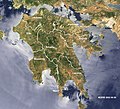
File:Peloponnese-Map satview BlueMarbleProject.jpg
Appearance

Size of this preview: 657 × 600 pixels. Other resolutions: 263 × 240 pixels | 526 × 480 pixels | 842 × 768 pixels | 1,200 × 1,095 pixels.
Original file (1,200 × 1,095 pixels, file size: 1.23 MB, MIME type: image/jpeg)
File history
Click on a date/time to view the file as it appeared at that time.
| Date/Time | Thumbnail | Dimensions | User | Comment | |
|---|---|---|---|---|---|
| current | 18:04, 4 November 2019 |  | 1,200 × 1,095 (1.23 MB) | Ulrichstill | size 1200x1095 |
| 13:55, 16 August 2005 |  | 800 × 730 (164 KB) | Ulrichstill | {{Information| |Description = Satview of en:Peloponnese, Part of Greece, in visible light. NASA-MODIS-Project Blue Marble. Names and borders added by de:Benutzer:ulrichstill. |Source = http://visibleearth.nasa.gov/view_rec.php?id=3232 |Date | |
| 11:42, 16 August 2005 |  | 800 × 730 (164 KB) | Ulrichstill | {{Information| |Description = Satview of Peloponnese, Part of Greece, in visible light. NASA-Project Blue Marble. Names and borders added by de:Benutzer:ulrichstill. |Source = http://visibleearth.nasa.gov/view_rec.php?id=3232 |Date = 2002-06- |
File usage
The following page uses this file:
Global file usage
The following other wikis use this file:
- Usage on als.wikipedia.org
- Usage on cs.wikipedia.org
- Usage on da.wikipedia.org
- Usage on de.wikipedia.org
- Usage on fo.wikipedia.org
- Usage on fr.wikipedia.org
- Usage on he.wikipedia.org
- Usage on hr.wikipedia.org
- Usage on hyw.wikipedia.org
- Usage on incubator.wikimedia.org
- Usage on is.wikipedia.org
- Usage on ja.wikipedia.org
- Usage on ku.wikipedia.org
- Usage on nl.wikipedia.org
- Usage on oc.wikipedia.org
- Usage on pnb.wikipedia.org
- Usage on rue.wikipedia.org
- Usage on simple.wikipedia.org
- Usage on vi.wikipedia.org
- Usage on zh.wikipedia.org


