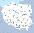
File:PL-MapaDK4.svg
Appearance

Size of this PNG preview of this SVG file: 617 × 600 pixels. Other resolutions: 247 × 240 pixels | 494 × 480 pixels | 790 × 768 pixels | 1,053 × 1,024 pixels | 2,107 × 2,048 pixels | 863 × 839 pixels.
Original file (SVG file, nominally 863 × 839 pixels, file size: 509 KB)
File history
Click on a date/time to view the file as it appeared at that time.
| Date/Time | Thumbnail | Dimensions | User | Comment | |
|---|---|---|---|---|---|
| current | 11:19, 21 July 2016 |  | 863 × 839 (509 KB) | Winnetou14 | a4 opened |
| 20:49, 2 September 2013 |  | 863 × 839 (509 KB) | Miko101 | drobne korekty | |
| 22:25, 24 August 2013 |  | 863 × 839 (490 KB) | Miko101 | zmiana wyglądu mapy, dodanie pozostałych byłych miast wojewódzkich oraz uaktualnienie przebiegu A4 i DK4 | |
| 23:17, 7 September 2012 |  | 616 × 581 (571 KB) | Miko101 | update | |
| 04:38, 18 July 2011 |  | 616 × 581 (255 KB) | Miko101 | {{Information |Description ={{en|1=Map of route of national road 4 in Poland. Map legend is available here.}} {{pl|1=Mapa przebiegu drogi krajowej nr 4. Legenda dostępna jest tutaj.} |
File usage
The following page uses this file:
Global file usage
The following other wikis use this file:
- Usage on eo.wikipedia.org
- Usage on it.wikipedia.org
- Usage on lmo.wikipedia.org
- Usage on nl.wikipedia.org
- Usage on pl.wikipedia.org
- Usage on sk.wikipedia.org
- Usage on uk.wikipedia.org
- Usage on vi.wikipedia.org
- Usage on www.wikidata.org
