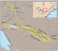
File:Ottawabonnecheregrabenmap.png
Appearance
Ottawabonnecheregrabenmap.png (600 × 525 pixels, file size: 446 KB, MIME type: image/png)
File history
Click on a date/time to view the file as it appeared at that time.
| Date/Time | Thumbnail | Dimensions | User | Comment | |
|---|---|---|---|---|---|
| current | 15:46, 17 December 2007 |  | 600 × 525 (446 KB) | Kmusser | Added relic pipes, Brent craters, extended OBG east |
| 15:22, 13 December 2007 |  | 571 × 500 (409 KB) | Kmusser | Added Timiskaming branch. | |
| 22:16, 12 December 2007 |  | 571 × 500 (400 KB) | Kmusser | {{Information |Description=This is a map of the Ottawa-Bonnechere Graben. Elevation data and U.S. boundaries from USGS, Canadian boundaries and hydrology from [[:en:Digital Chart of the World|Digital Chart of |
File usage
The following 5 pages use this file:
Global file usage
The following other wikis use this file:
- Usage on af.wikipedia.org
- Usage on ar.wikipedia.org
- Usage on de.wikipedia.org
- Usage on fr.wikipedia.org
- Usage on he.wikipedia.org
- Usage on ms.wikipedia.org
- Usage on sl.wikipedia.org
- Usage on uk.wikipedia.org
- Usage on vi.wikipedia.org
- Usage on www.wikidata.org

