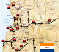
File:Op Savannah Map.png
Appearance

Size of this preview: 688 × 600 pixels. Other resolutions: 275 × 240 pixels | 551 × 480 pixels | 718 × 626 pixels.
Original file (718 × 626 pixels, file size: 956 KB, MIME type: image/png)
File history
Click on a date/time to view the file as it appeared at that time.
| Date/Time | Thumbnail | Dimensions | User | Comment | |
|---|---|---|---|---|---|
| current | 21:24, 7 February 2015 |  | 718 × 626 (956 KB) | Katangais | added MPLA positions near Luanda and Caxito, respectively |
| 21:21, 7 February 2015 |  | 718 × 626 (959 KB) | Katangais | {{Information |Description ={{en|1=Cropped version of a CIA public domain image. Route of axis for South African armoured columns during Operation Savannah (1975-1976). Cropped for an article on Operation Savannah. Limited contextual relevance to o... |
File usage
The following 3 pages use this file:
Global file usage
The following other wikis use this file:
- Usage on af.wikipedia.org
- Usage on es.wikipedia.org
- Usage on he.wikipedia.org
- Usage on pt.wikipedia.org


