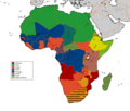
File:Official LanguagesMap-Africa .png
Appearance

Size of this preview: 707 × 599 pixels. Other resolutions: 283 × 240 pixels | 566 × 480 pixels | 939 × 796 pixels.
Original file (939 × 796 pixels, file size: 45 KB, MIME type: image/png)
File history
Click on a date/time to view the file as it appeared at that time.
| Date/Time | Thumbnail | Dimensions | User | Comment | |
|---|---|---|---|---|---|
| current | 10:44, 16 March 2018 |  | 939 × 796 (45 KB) | Maphobbyist | Updates Morocco, Algeria and Sudan |
| 18:32, 15 March 2018 |  | 939 × 796 (48 KB) | Maphobbyist | Check | |
| 22:57, 14 March 2018 |  | 939 × 796 (48 KB) | Maphobbyist | South Sudan border | |
| 11:40, 27 April 2008 |  | 720 × 784 (186 KB) | Ant75 | {{Information |Description= Official Languages of Africa. |Source= Wikipedia |Date= 27 April 2008 |Author= |Permission= |other_versions= }} |
File usage
The following page uses this file:
Global file usage
The following other wikis use this file:


