File:Oakland old oakland locator map.png
Appearance
Oakland_old_oakland_locator_map.png (540 × 540 pixels, file size: 102 KB, MIME type: image/png)
File history
Click on a date/time to view the file as it appeared at that time.
| Date/Time | Thumbnail | Dimensions | User | Comment | |
|---|---|---|---|---|---|
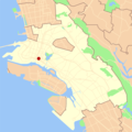
| current | 05:59, 6 September 2006 |  | 540 × 540 (102 KB) | Daniel Olsen | Uploading map of Old Oakland based on maps by Nogood. A blank map can be found at Image:Oakland blank locator map. |
| 13:21, 3 March 2006 |  | 540 × 540 (42 KB) | Nogood | Map showing the location of Old Oakland in the city of Oakland, California. Created by User:Nogood using U.S. Census Bureau data. |
File usage
The following 2 pages use this file:


