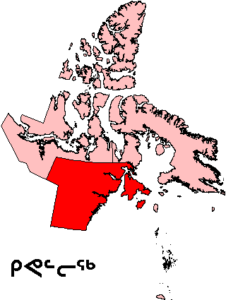
File:Nunavut Kivalliq Region.png
Appearance
Nunavut_Kivalliq_Region.png (320 × 425 pixels, file size: 11 KB, MIME type: image/png)
File history
Click on a date/time to view the file as it appeared at that time.
| Date/Time | Thumbnail | Dimensions | User | Comment | |
|---|---|---|---|---|---|
| current | 19:58, 16 August 2006 |  | 320 × 425 (11 KB) | TeVe | {{Information |Description=Map of Kivalliq Region in Nunavut, Canada |Source=[http://en.wikipedia.org/wiki/Image:Nunavut_Kivalliq_Region.png English Wikipedia] |Date=2 August 2004 |Author=en:User:Keith Edkins |Permission=GFDL content from English Wik |
File usage
The following 86 pages use this file:
- Aberdeen Lake (Nunavut)
- Aiqqujat Islands
- Airartuuq Island
- Akreavenek Island
- Apqusiurniq Island
- Ascension Islands
- Austin Island
- Back Peninsula
- Baker Lake (Nunavut)
- Bay of Gods Mercy
- Bell Peninsula
- Beverly Lake (Nunavut)
- Bibby Island
- Boas River
- Boulder Island
- Broken Islands
- Camp Cove Island
- Cape Fullerton
- Cape Pembroke (Nunavut)
- Centre Island (Nunavut)
- Chesterfield Inlet
- Comer Strait
- Committee Bay
- Copperneedle River
- Deer Island (Kivalliq Region)
- Dionne Lake
- Dunne Foxe Island
- East Pen Island
- Ennadai
- Evans Strait
- Ferguson River (Nunavut)
- Fisher Strait
- Flattop Island (Nunavut)
- Frozen Strait
- Hanbury Island
- Harry Gibbons Migratory Bird Sanctuary
- Hayes River (Nunavut)
- Illusive Islands
- Imiligaarjuk Island
- Imilijjuaq Island
- Inuujarvik Territorial Park
- Iqalugaarjuup Nunanga Territorial Park
- Irik Island
- Iripajuk Island
- Ivuniraarjuq Island
- Kaminak Lake
- Kasba Lake
- Kayak Island (Nunavut)
- Keewatin Region
- Maguse Lake
- Maguse River
- Maittuq
- Mallery Lake
- McConnell River
- McConnell River Migratory Bird Sanctuary
- Mistake Bay
- Moor Island
- Mount Minto (Nunavut)
- Nagjuttuuq
- Native Point
- Nevill Bay
- North Imilit Island
- North Midway Island
- Padlei
- Pintail Island
- Pitsiulartok
- Pork Peninsula
- Princess Mary Lake
- Promise Island
- Qikiqtaaluk (Foxe Basin)
- Reference Island
- Rockhouse Island
- Roes Welcome Sound
- Sentry Island
- South Imilit Island
- South Midway Island
- Tavani, Nunavut
- Tebesjuak Lake
- Tulemalu Lake
- Wag Islands
- Wager Bay
- Walrus Island (Fisher Strait)
- Walrus Island (Hudson Bay)
- Wilson Bay
- Yathkyed Lake
- Template:KivalliqNU-geo-stub
Global file usage
The following other wikis use this file:
- Usage on ar.wikipedia.org
- Usage on ast.wikipedia.org
- Usage on ca.wikipedia.org
- Usage on de.wikipedia.org
- Usage on es.wikipedia.org
- Usage on eu.wikipedia.org
- Usage on fi.wikipedia.org
- Usage on frr.wikipedia.org
- Usage on fr.wikipedia.org
- Usage on it.wikipedia.org
- Usage on ja.wikipedia.org
- Usage on nn.wikipedia.org
- Usage on pl.wikipedia.org
- Usage on ru.wikipedia.org
- Usage on sr.wikipedia.org
- Usage on uk.wikipedia.org
- Usage on www.wikidata.org
- Usage on zh.wikipedia.org


