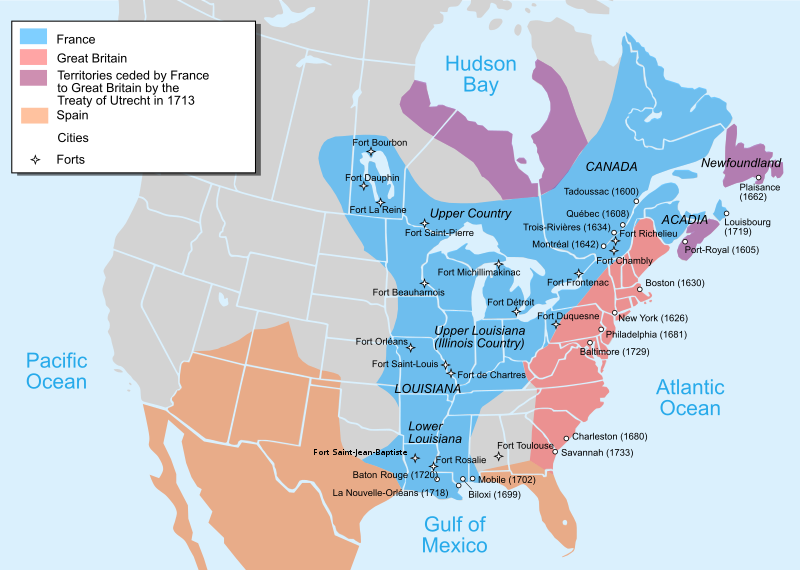
File:Nouvelle-France map-en.svg
Appearance

Size of this PNG preview of this SVG file: 800 × 570 pixels. Other resolutions: 320 × 228 pixels | 640 × 456 pixels | 1,024 × 730 pixels | 1,280 × 912 pixels | 2,560 × 1,824 pixels | 1,530 × 1,090 pixels.
Original file (SVG file, nominally 1,530 × 1,090 pixels, file size: 586 KB)
File history
Click on a date/time to view the file as it appeared at that time.
| Date/Time | Thumbnail | Dimensions | User | Comment | |
|---|---|---|---|---|---|
| current | 22:23, 27 December 2022 |  | 1,530 × 1,090 (586 KB) | Tcr25 | remove stray circle from Saskatchewan |
| 16:09, 14 December 2022 |  | 1,530 × 1,090 (586 KB) | Tcr25 | plain SVG instead of Inkscape | |
| 13:24, 21 September 2021 |  | 1,530 × 1,090 (590 KB) | Tcr25 | Placed Fort Rosalie in proper location; added Fort St. Jean Baptiste (Natchitoches) | |
| 14:11, 10 October 2013 |  | 1,530 × 1,090 (550 KB) | Begoon | Reverted to version as of 14:02, 10 October 2013 | |
| 14:08, 10 October 2013 |  | 1,530 × 1,090 (265 KB) | Begoon | revert to compare rsvg render | |
| 14:02, 10 October 2013 |  | 1,530 × 1,090 (550 KB) | Begoon | revert for now - I'll play some more... | |
| 13:58, 10 October 2013 |  | 1,530 × 1,090 (265 KB) | Begoon | tweak a couple of label positions | |
| 13:53, 10 October 2013 |  | 1,530 × 1,090 (265 KB) | Begoon | actually - something spooky about this file ever since gradient was changed. I'm reverting to version with gradient, because it's consistent with other maps in series. Subsequent change to Fort Toulouse replicated, Mexico landmass added, layers fixed. | |
| 13:10, 10 October 2013 |  | 1,530 × 1,090 (550 KB) | Begoon | cities layer is wrong - try again | |
| 11:35, 10 October 2013 |  | 1,530 × 1,090 (633 KB) | Begoon | fix layers after addition |
File usage
The following 47 pages use this file:
- Americas–France relations
- Canada
- Canada–United States relations
- Colonial history of the United States
- European colonization of the Americas
- Former colonies and territories in Canada
- Franco-Indian alliance
- French Americans
- French Louisianians
- French and Indian War
- French immigration to Puerto Rico
- Great Britain in the Seven Years' War
- History of Louisiana
- History of Michigan
- History of Pennsylvania
- History of St. Louis
- History of the United States
- Louis XV
- Louisiana
- Louisiana (New France)
- Louisiana Creole people
- Military history of Canada
- Mississippi River
- New France
- North American fur trade
- Northern Michigan
- Outline of the history of the United States
- Peace of Utrecht
- Queen Anne's War
- Seven Years' War
- Spanish Texas
- Timeline of European imperialism
- United States
- Voyageurs
- Talk:Ming dynasty/Archive 2
- Talk:New France/Archive 1
- Talk:United States/Archive 93
- User:CactusJack/USA
- User:Falcaorib/Canada, United States and Mexico
- User:HamzaK8/sandbox
- User:Kayoty/sandbox
- Wikipedia:Graphics Lab/Map workshop/Archive/Dec 2013
- Wikipedia:Graphics Lab/Map workshop/Archive/Jan 2011
- Portal:Canada/Selected picture
- Portal:Louisiana
- Portal:Michigan
- Portal:Pennsylvania
Global file usage
The following other wikis use this file:
- Usage on af.wikipedia.org
- Usage on an.wikipedia.org
- Usage on ar.wikipedia.org
- Usage on azb.wikipedia.org
- Usage on az.wikipedia.org
- Usage on bg.wikipedia.org
- Usage on bn.wikipedia.org
- Usage on bn.wikibooks.org
- Usage on cs.wikipedia.org
- Usage on cy.wikipedia.org
- Usage on da.wikipedia.org
- Usage on en.wikibooks.org
- Usage on es.wikipedia.org
- Usage on et.wikipedia.org
- Usage on eu.wikipedia.org
- Usage on fa.wikipedia.org
- Usage on fi.wikipedia.org
- Usage on fr.wikipedia.org
- Usage on gpe.wikipedia.org
- Usage on he.wikipedia.org
- Usage on hu.wikipedia.org
- Usage on hy.wikipedia.org
- Usage on ia.wikipedia.org
- Usage on io.wikipedia.org
- Usage on it.wikipedia.org
- Usage on ja.wikipedia.org
View more global usage of this file.


