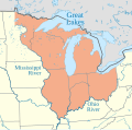
File:Northwest Territory locator map (1787).svg
Appearance

Size of this PNG preview of this SVG file: 512 × 505 pixels. Other resolutions: 243 × 240 pixels | 487 × 480 pixels | 779 × 768 pixels | 1,038 × 1,024 pixels | 2,076 × 2,048 pixels.
Original file (SVG file, nominally 512 × 505 pixels, file size: 248 KB)
File history
Click on a date/time to view the file as it appeared at that time.
| Date/Time | Thumbnail | Dimensions | User | Comment | |
|---|---|---|---|---|---|
| current | 18:15, 5 June 2023 |  | 512 × 505 (248 KB) | Isochrone | (grr) |
| 18:12, 5 June 2023 |  | 512 × 505 (248 KB) | Isochrone | actually! | |
| 18:10, 5 June 2023 |  | 512 × 505 (248 KB) | Isochrone | fix font | |
| 18:09, 5 June 2023 |  | 512 × 505 (248 KB) | Isochrone | Uploaded a work by {{u|Isochrone}} from {{own using}}: * https://project.geo.msu.edu/geogmich/treaties.html {{Attrib|Usa edcp location map.svg}} with UploadWizard |
File usage
The following 4 pages use this file:
Global file usage
The following other wikis use this file:
- Usage on ar.wikipedia.org
- Usage on ast.wikipedia.org
- Usage on bn.wikipedia.org
- Usage on da.wikipedia.org
- Usage on es.wikipedia.org
- Usage on gl.wikipedia.org
- Usage on id.wikipedia.org
- Usage on ru.wikipedia.org
- Usage on www.wikidata.org
