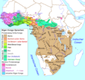
File:Niger-Kongo-Karte.png
Appearance

Size of this preview: 635 × 599 pixels. Other resolutions: 254 × 240 pixels | 509 × 480 pixels | 814 × 768 pixels | 1,207 × 1,139 pixels.
Original file (1,207 × 1,139 pixels, file size: 138 KB, MIME type: image/png)
File history
Click on a date/time to view the file as it appeared at that time.
| Date/Time | Thumbnail | Dimensions | User | Comment | |
|---|---|---|---|---|---|
| current | 20:57, 15 March 2018 |  | 1,207 × 1,139 (138 KB) | Maphobbyist | South Sudan border |
| 00:56, 4 July 2015 |  | 1,207 × 1,139 (137 KB) | Kwamikagami | rm. Khoisan | |
| 20:29, 28 October 2007 |  | 1,207 × 1,139 (76 KB) | Ulamm | ||
| 08:52, 26 October 2007 |  | 1,207 × 1,139 (77 KB) | Ulamm | == Summary == {{Information |Description=Map of the Niger-Congo-languages und Khoi-San-languages in Afrika / Karte der Niger-Kongo-Sprachen und Khoisan-Sprachen in Afrika |Source=Relaunch (especially larger letters) of [[:de:Image:Karte_der_Niger-Kongo-Sp |
File usage
No pages on the English Wikipedia use this file (pages on other projects are not listed).
Global file usage
The following other wikis use this file:
- Usage on bg.wikipedia.org
- Usage on de.wikipedia.org
- Usage on eo.wikipedia.org
- Usage on frr.wikipedia.org
- Usage on ilo.wikipedia.org
- Usage on lv.wikipedia.org
- Usage on pt.wikipedia.org
