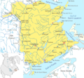
File:New Brunswick map general.png
Appearance

Size of this preview: 649 × 600 pixels. Other resolutions: 260 × 240 pixels | 519 × 480 pixels | 831 × 768 pixels | 1,108 × 1,024 pixels | 1,659 × 1,533 pixels.
Original file (1,659 × 1,533 pixels, file size: 1.4 MB, MIME type: image/png)
File history
Click on a date/time to view the file as it appeared at that time.
| Date/Time | Thumbnail | Dimensions | User | Comment | |
|---|---|---|---|---|---|
| current | 16:37, 26 January 2008 |  | 1,659 × 1,533 (1.4 MB) | Qyd | wash out color (better for superimpose) |
| 00:37, 16 January 2008 |  | 1,659 × 1,533 (1.26 MB) | Qyd | {{Information |Description=Map of New Brunswick |Source=Translated and cropped from Image:Nouveau-Brunswick.png |Date=Jan 2008 |Author= Qyd |Permission=cc-by-3 |other_versions=<gallery> Image:Nouveau-Brunswick.png|French version Image:Ne |
File usage
The following 3 pages use this file:
Global file usage
The following other wikis use this file:
- Usage on ar.wikipedia.org
- Usage on azb.wikipedia.org
- Usage on es.wikipedia.org
- Usage on fa.wikipedia.org
- Usage on fr.wikipedia.org
- Usage on is.wikipedia.org
- Usage on it.wikipedia.org
- Usage on ja.wikipedia.org
- Usage on ku.wikipedia.org
- Usage on nl.wikipedia.org
- Usage on ru.wikipedia.org
- Usage on uk.wikipedia.org
- Usage on war.wikipedia.org
- Usage on zh-min-nan.wikipedia.org
- Usage on zh.wikipedia.org


