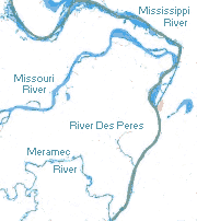
File:Navigable rivers near St Louis MO.svg
Appearance

Size of this PNG preview of this SVG file: 561 × 599 pixels. Other resolutions: 225 × 240 pixels | 449 × 480 pixels | 719 × 768 pixels | 959 × 1,024 pixels | 1,918 × 2,048 pixels | 779 × 832 pixels.
Original file (SVG file, nominally 779 × 832 pixels, file size: 116 KB)
File history
Click on a date/time to view the file as it appeared at that time.
| Date/Time | Thumbnail | Dimensions | User | Comment | |
|---|---|---|---|---|---|
| current | 23:32, 12 October 2009 |  | 779 × 832 (116 KB) | Kbh3rd | Colors |
| 01:41, 5 October 2009 |  | 779 × 832 (118 KB) | Kbh3rd | {{Information |Description={{en|1=Navigable rivers near St. Louis, Missouri. This map uses a polyconic projection on -90°.}} |Source={{own}} |Author=Kbh3rd |Date=2 |
File usage
The following page uses this file:

