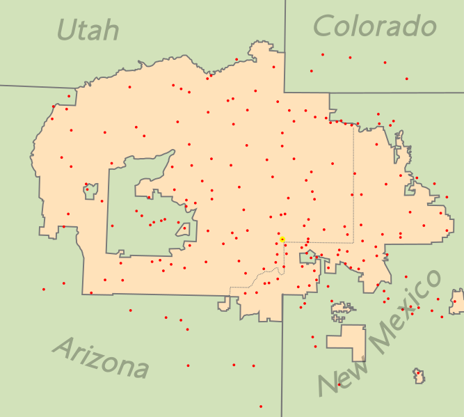
File:NavajoNation map en.svg
Appearance

Size of this PNG preview of this SVG file: 667 × 599 pixels. Other resolutions: 267 × 240 pixels | 534 × 480 pixels | 855 × 768 pixels | 1,139 × 1,024 pixels | 2,279 × 2,048 pixels | 1,729 × 1,554 pixels.
Original file (SVG file, nominally 1,729 × 1,554 pixels, file size: 193 KB)
File history
Click on a date/time to view the file as it appeared at that time.
| Date/Time | Thumbnail | Dimensions | User | Comment | |
|---|---|---|---|---|---|
| current | 20:21, 25 September 2010 |  | 1,729 × 1,554 (193 KB) | Seb az86556 | {{Information |Description={{en|1=map of locations on the Navajo Nation }} |Source={{own}} |Author=Seb az86556 |Date=2010-09-25 |Permission= |other_versions= }} |
File usage
The following 4 pages use this file:
Global file usage
The following other wikis use this file:
- Usage on ca.wikipedia.org
- Bitter Springs
- Burnside (Arizona)
- Cameron (Arizona)
- Chilchinbito
- Chinle
- Dennehotso
- Dilkon
- Fort Defiance
- Ganado (Arizona)
- Greasewood
- Houck
- Jeddito
- Kaibito
- Kayenta
- Lechee
- Leupp
- Lukachukai
- Many Farms
- Nazlini
- Pinon (Arizona)
- Red Mesa
- Rock Point
- Rough Rock
- Round Rock (Arizona)
- Sawmill
- Shonto
- St. Michaels (Arizona)
- Steamboat
- Teec Nos Pos
- Tonalea
- Tsaile
- Tuba City
- Window Rock
- Alamo (Nou Mèxic)
- Beclabito
- Brimhall Nizhoni
- Church Rock
- Crownpoint
- Crystal (Nou Mèxic)
- Nakaibito
- Naschitti
- Navajo (Nou Mèxic)
- Nenahnezad
- Newcomb
- Ojo Amarillo
- Pueblo Pintado
- Sanostee
- Sheep Springs
- Tohatchi
- Tse Bonito
View more global usage of this file.

