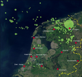
File:Natural gas NL.png
Appearance

Size of this preview: 639 × 599 pixels. Other resolutions: 256 × 240 pixels | 512 × 480 pixels | 819 × 768 pixels | 1,100 × 1,032 pixels.
Original file (1,100 × 1,032 pixels, file size: 1.28 MB, MIME type: image/png)
File history
Click on a date/time to view the file as it appeared at that time.
| Date/Time | Thumbnail | Dimensions | User | Comment | |
|---|---|---|---|---|---|
| current | 15:31, 21 June 2008 |  | 1,100 × 1,032 (1.28 MB) | Classical geographer | {{Information |Description=Map of Natural Gas concessions of the NAM in the Netherlands. Source of concessions is Shell/NAM, at http://www-static.shell.com/static/nam-nl/images/concessiekaart.gif. |Source=*[[:Image:Satellite_image_of_the_Netherlands_in_Ma |
File usage
The following 4 pages use this file:
Global file usage
The following other wikis use this file:
- Usage on az.wikipedia.org
- Usage on cs.wikipedia.org
- Usage on de.wikipedia.org
- Usage on de.wikinews.org
- Usage on el.wikipedia.org
- Usage on fr.wikipedia.org
- Usage on fy.wikipedia.org
- Usage on ko.wikipedia.org
- Usage on my.wikipedia.org
- Usage on nl.wikipedia.org
- Usage on nl.wikibooks.org
- Usage on nl.wikinews.org
- Usage on nl.wiktionary.org
- Usage on ro.wikipedia.org
- Usage on sv.wikipedia.org
- Usage on te.wikipedia.org
- Usage on th.wikipedia.org
- Usage on tr.wikipedia.org
- Usage on uk.wikipedia.org
- Usage on uz.wikipedia.org
- Usage on vi.wikipedia.org

