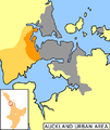
File:NZ-WaitakereCity.png
Appearance

Size of this preview: 504 × 600 pixels. Other resolutions: 202 × 240 pixels | 589 × 701 pixels.
Original file (589 × 701 pixels, file size: 95 KB, MIME type: image/png)
File history
Click on a date/time to view the file as it appeared at that time.
| Date/Time | Thumbnail | Dimensions | User | Comment | |
|---|---|---|---|---|---|
| current | 15:23, 31 May 2006 |  | 589 × 701 (95 KB) | 2000 | == Summary == Uploaded from the English Wikipedia, uploaded there by user:Grutness Map of Auckland urban area, Waitakere City highlighted (dark orange=populated; light orange=rural areas) Category:Maps of New Zealand [[en:Image:NZ-WaitakereCity.p |
File usage
The following page uses this file:
