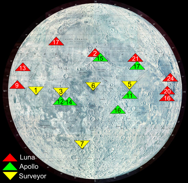
File:Moon landing map surveyor.svg
Appearance

Size of this PNG preview of this SVG file: 616 × 599 pixels. Other resolutions: 247 × 240 pixels | 493 × 480 pixels | 790 × 768 pixels | 1,053 × 1,024 pixels | 2,105 × 2,048 pixels | 1,100 × 1,070 pixels.
Original file (SVG file, nominally 1,100 × 1,070 pixels, file size: 382 KB)
File history
Click on a date/time to view the file as it appeared at that time.
| Date/Time | Thumbnail | Dimensions | User | Comment | |
|---|---|---|---|---|---|
| current | 20:07, 31 January 2011 |  | 1,100 × 1,070 (382 KB) | X-romix | All labels |
| 23:12, 29 January 2011 |  | 1,100 × 1,070 (335 KB) | X-romix | correct SVG | |
| 23:09, 29 January 2011 |  | 744 × 1,052 (334 KB) | X-romix | {{Information |Description=Map shows landing sites of Surveyor, Apollo and Luna missions source: http://nssdc.gsfc.nasa.gov/planetary/lunar/moon_landing_map.jpg |Source=*File:Moon_landing_map.jpg |Date=2011-01-29 23:08 (UTC) |Author=*[[:File:Moon_l |
File usage
The following page uses this file:
Global file usage
The following other wikis use this file:
- Usage on ca.wikipedia.org
- Usage on cs.wikipedia.org
- Usage on et.wikipedia.org
- Usage on fr.wikipedia.org
- Usage on he.wikipedia.org
- Usage on id.wikipedia.org
- Usage on it.wikipedia.org
- Usage on lv.wikipedia.org
- Usage on pt.wikipedia.org
- Usage on ro.wikipedia.org
- Usage on tr.wikipedia.org


