
File:Moffat route.png

Size of this preview: 800 × 374 pixels. Other resolutions: 320 × 150 pixels | 640 × 299 pixels | 1,024 × 478 pixels | 1,280 × 598 pixels | 3,388 × 1,583 pixels.
Original file (3,388 × 1,583 pixels, file size: 1.97 MB, MIME type: image/png)
| This is a file from the Wikimedia Commons. Information from its description page there is shown below. Commons is a freely licensed media file repository. You can help. |
Summary
| Description |
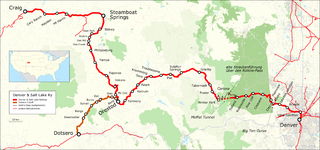
English: Map of Moffat Route as built by the Denver and Salt Lake Railway and Denver & Rio Grande Western Railroad. Map key in German. |
| Date | |
| Source |
Map was created by using
|
| Author |
|
Licensing
I, the copyright holder of this work, hereby publish it under the following license:
This file is licensed under the Creative Commons Attribution 3.0 Unported license.
- You are free:
- to share – to copy, distribute and transmit the work
- to remix – to adapt the work
- Under the following conditions:
- attribution – You must give appropriate credit, provide a link to the license, and indicate if changes were made. You may do so in any reasonable manner, but not in any way that suggests the licensor endorses you or your use.
| This work is licensed under the Open Database License (summary). |
File history
Click on a date/time to view the file as it appeared at that time.
| Date/Time | Thumbnail | Dimensions | User | Comment | |
|---|---|---|---|---|---|
| current | 00:12, 27 October 2016 | | 3,388 × 1,583 (1.97 MB) | Kopiersperre | optipng |
| 19:34, 3 March 2016 |  | 3,388 × 1,583 (2.73 MB) | Pechristener | zweiter Anlauf Typofix | |
| 19:30, 3 March 2016 |  | 3,775 × 1,764 (2.84 MB) | Pechristener | Typo fix: Orsedot-->Orestod | |
| 18:34, 2 March 2016 |  | 3,388 × 1,583 (2.73 MB) | Pechristener | == {{int:filedesc}} == {{Information |Description={{en|1=Map of Moffat Route as built by the Denver and Salt Lake Railway and Denver & Rio Grande Western Railroad. Map key in German.}} |Source=Map was created by using * [http://www.openstreetmap.org/... |
File usage
The following page uses this file:
Global file usage
The following other wikis use this file:
- Usage on de.wikipedia.org
- Usage on www.wikidata.org