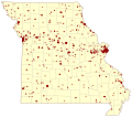
File:Missouri Natl Reg Historic Places v1.svg
Appearance

Size of this PNG preview of this SVG file: 676 × 599 pixels. Other resolutions: 271 × 240 pixels | 541 × 480 pixels | 866 × 768 pixels | 1,155 × 1,024 pixels | 2,310 × 2,048 pixels | 820 × 727 pixels.
Original file (SVG file, nominally 820 × 727 pixels, file size: 431 KB)
File history
Click on a date/time to view the file as it appeared at that time.
| Date/Time | Thumbnail | Dimensions | User | Comment | |
|---|---|---|---|---|---|
| current | 05:53, 8 November 2009 |  | 820 × 727 (431 KB) | Kbh3rd | Added missing XML comment terminator. |
| 05:51, 8 November 2009 | No thumbnail | (431 KB) | Kbh3rd | {{Information |Description={{en|1=Map of Missouri counties showing the point location of sites certified by the National Park Service as included on the [[National Register of Historic Places|National Register of |
File usage
The following page uses this file:
